PHOENIX SKY HARBOR INTL (PHX)(KPHX) P (ANG) 3 E UTC–7 N33°26.06′ W112°00.70′
1135 B TPA–See Remarks LRA Class I, ARFF Index D NOTAM FILE PHX
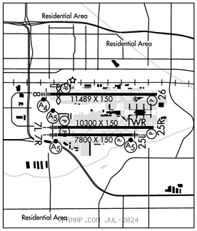
RWY 08–26: H11489X150 (CONC–GRVD) S–30, D–200, 2S–175, 2D–455, 2D/2D2–965 PCN 74 R/B/W/T HIRL
RWY 08: MALSF. PAPI(P4L)–GA 3.0° TCH 69′. Thld dsplcd 898′. Bldg.
RWY 26: REIL. PAPI(P4L)–GA 3.0° TCH 71′. Road. Rgt tfc.
RWY 07L–25R: H10300X150 (CONC–GRVD) S–30, D–235, 2S–175, 2D–435, 2D/2D2–940 PCN 70 R/B/W/T HIRL
RWY 07L: MALSR. PAPI(P4L)–GA 3.0° TCH 73′. RVR–T Pole. Rgt tfc.
RWY 25R: PAPI(P4L)–GA 3.0° TCH 70′. RVR–R Antenna.
RWY 07R–25L: H7800X150 (CONC–GRVD) S–30, D–200, 2S–175, 2D–400, 2D/2D2–1010 PCN 79 R/B/W/T HIRL
RWY 07R: MALSR. PAPI(P4L)–GA 3.0° TCH 70′. Pole.
RWY 25L: MALSR. PAPI(P4L)–GA 3.0° TCH 66′. Antenna.
RUNWAY DECLARED DISTANCE INFORMATION
RWY 07L:TORA–10300 TODA–10300 ASDA–10300 LDA–10300
RWY 07R:TORA–7800 TODA–7800 ASDA–7800 LDA–7800
RWY 08: TORA–11489 TODA–11489 ASDA–11489 LDA–10591
RWY 25L:TORA–7800 TODA–7800 ASDA–7800 LDA–7800
RWY 25R:TORA–10300TODA–10300 ASDA–10300 LDA–10300
RWY 26: TORA–11489 TODA–11489 ASDA–11489 LDA–11489
SERVICE: S4 FUEL 100LL, JET A OX 1, 2, 3, 4 MILITARY– JASU 1(MD–3M) 1(MA–1A) FUEL J4–Ltd supply (MIL), A+ (C602–273–3770.) (NC–100LL, A) FLUID LPOX LOX OIL O–148 (Mil)
NOISE: Noise abatement proc in efct. Eng runs NA wo prior coord with airside ops.
AIRPORT REMARKS: Attended continuously. ASDE–X in use. Opr parrot with alt rprtg mode and ADS–B if equipped enabled on all arpt sfcs. TPA–2135(1000) lgt acft and non–turbo jets; 2635(1500) heavy acft and turbojets. Twy R & ptns of Twy S & Twy T blw atct are non vsb fm atct. Twy R midpt ovhd train bridge prvds 82 ft 4 in clnc. Twy F btn twy int G2 & G3 clsd to wingspan gtr than 135 ft. Twys C btn S & R, D btn D2 & D6, D3, D4, D5, D btn D8 & T, D9, H btn Twy H4 & Twy H7, H5, H6, H7 clsd to acft wingspan gtr than 171 ft. Twys A btn A3 & A10, A4, A5, A6, A7, A8, A9, A12, F btn G2 & G3, D13 clsd to wingspan gtr than 135 ft. Twys D btn S and D13, D10, D11, D12 clsd to acft wingspan more than 118 ft. Experimental or gnd dmnstn NA wo prior apvl – airside ops. ANG: offl bus only; bash phase II in eff 1 Mar thru 31 May & 1 Aug thru 31 Oct; ltd ramp space avbl; FBO–602–273–3770. Wingspan 215 ft or gtr Group VI PPR – 602–272–2008 for follow–me svc tax to & fm ramp & rwy. Prac apch, stop & go, taxi back & tgl NA. Otr trng ops NA wo prior written approval – 602–272–2008. No engine runs on arpt without prior coord with airside ops. Intl ldg rights rqr U.S. Cust & Border Protection notification 48 hrs prior to lndg. Intl gate use rqr cdn with arpt ops 48 hr prior to arr. Review hot spot info on arpt diagram. General aviation should ctc arpt mgr 602–273–3300 as to how to view/review arpt video. Rwy status lgts in opr. Gen info – 602–273–3302. Ldg fee: ovngt prkg fee. Fee for charters, travel club & revenue producing acft. Flight Notification Service (ADCUS) available.
AIRPORT MANAGER: 602-273-3302
WEATHER DATA SOURCES: ASOS (602) 231–8557 TDWR.
COMMUNICATIONS: D–ATIS 127.575
RCO 122.2 (PRESCOTT RADIO)
®APP/DEP CON 124.1 (119°–138° 7500′–14,500′) (192°–263° 7500′–12,500′) 119.2 (319°–057° 7500′ and abv) 120.7 (319°–057° blo 7500′) 123.7 (119°–138° blo 7500′) (139°–191° blo 8500′) 124.9 (058°–118° blo 10,500′) 126.8 (058°–118° 10,500′ and abv) (119°–138° abv 14,500′) (139°–191° 8500′ and above) (192°–263° abv 12,500′) 128.65 (340°–079° abv 5,500′) 126.375
TOWER 118.7 (Rwy 08–26) 120.9 (Rwy 07R–25L and Rwy 07L–25R) GND CON 119.75 (North) 132.55 (South)
CLNC DEL 118.1
CPDLC (LOGON KUSA)
PDC
AIRSPACE: CLASS B See VFR Terminal Area Chart.
VOR TEST FACILITY (VOT) 109.0
RADIO AIDS TO NAVIGATION: NOTAM FILE PRC.
(H) (H) VORTACW 115.6 PXR Chan 103 N33°25.98′ W111°58.21′ 260° 2.1 NM to fld. 1184/12E.
VOR unusable:
000°–015° byd 33 NM blo 11,000′
015°–034° byd 33 NM blo 10,000′
090°–100° byd 15 NM blo 8,000′
185°–190° byd 30 NM blo 8,000′
185°–190° byd 38 NM blo 9,000′
190°–230° byd 20 NM blo 10,000′
345°–000° byd 33 NM blo 10,000′
345°–034° byd 10 NM blo 6,000′
345°–034° byd 20 NM blo 8,000′
TACAN AZIMUTH unusable:
000°–015° byd 33 NM blo 11,000′
015°–034° byd 33 NM blo 10,000′
090°–100° byd 15 NM blo 8,000′
185°–190° byd 30 NM blo 8,000′
185°–190° byd 38 NM blo 9,000′
190°–230° byd 20 NM blo 10,000′
345°–000° byd 33 NM blo 11,000′
345°–034° byd 10 NM blo 6,000′
345°–034° byd 20 NM blo 8,000′
DME unusable:
000°–015° byd 33 NM blo 11,000′
015°–034° byd 33 NM blo 10,000′
090°–100° byd 15 NM blo 8,000′
185°–190° byd 30 NM blo 8,000′
185°–190° byd 38 NM blo 9,000′
190°–230° byd 20 NM blo 10,000′
215°–315°
345°–000° byd 33 NM blo 11,000′
345°–034° byd 10 NM blo 6,000′
345°–034° byd 20 NM blo 8,000′
ILS/DME 111.5 I–PHX Chan 52 Rwy 07L. Class IE.
ILS/DME 110.75 I–AHA Chan 44(Y) Rwy 07R. Class ID. DME also serves RJG ILS Rwy 25L.
ILS/DME 111.75 I–SYQ Chan 54(Y) Rwy 08. Class IB. LOC unusable 25° left of course. Autopilot coupled apch not applicable blw 1,307′ MSL (0.3 NM).
ILS/DME 110.75 I–RJG Chan 44(Y) Rwy 25L. Class IT. DME also serves AHA ILS Rwy 7R.
ILS/DME 111.75 I–CWJ Chan 54(Y) Rwy 26. Class IB.