JACKSONVILLE
CECIL (VQQ)(KVQQ) P (ARNG) 0 N UTC–5(–4DT) N30°13.13′ W81°52.63′ 80 B NOTAM FILE VQQ
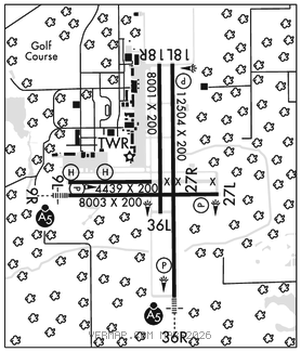
RWY 18L–36R: H12504X200 (ASPH–CONC) PCN 59 R/B/W/T HIRL
RWY 18L: REIL. PAPI(P4L)–GA 3.0° TCH 66′. Trees.
RWY 36R: MALSR. PAPI(P4L)–GA 3.0° TCH 66′. Trees.
RWY 09R–27L: H8003X200 (ASPH–CONC) PCN 21 F/A/X/T HIRL
RWY 09R: MALSR. PAPI(P4L)–GA 3.0° TCH 68′. Trees.
RWY 27L: REIL. PAPI(P4L)–GA 3.0° TCH 67′. Trees.
RWY 18R–36L: H8001X200 (ASPH–CONC) PCN 21 F/A/Y/T
RWY 18R: Trees.
RWY 09L–27R: H4439X200 (ASPH–CONC) PCN 27 R/B/X/T
RWY 09L: Trees.
SERVICE: S4 FUEL 100LL, JET A1+ OX1, 3, 4 LGT When ATCT clsd ACTVT MALSR Rwy 09R and 36R; REIL Rwy 18L and Rwy 27L; HIRL Rwy 18L–36R, Rwy 09R–27L–CTAF. MILITARY–FUEL A+ (Avbl H24 Mon–Fri, 1100–0400Z‡ Sat and Sun, and hol C904–317–6550. 130.925. OT 12 hr PN rqr and $60 fee per occurence.) (NC–100LL, A).
AIRPORT REMARKS: Attended Mon–Fri 1200–0400Z‡, Sat–Sun 1200–0200Z‡. Wildlife invof arpt. VTOL ops not auth. Dalgt gldr ops 6000 ft & blw; Herlong Recreational 5 NM NE. 180° turn on asph ptns of rwy by P–3 or larger na. Mil carrier break na. Hold shrt sign Rwy 09L–27R & Rwy 18R–36L unlgtd. Rwy 09L–27R rstd to fixed wing acft 12,500 lbs and blw. Rwy 18R–36L rstd to acft with wingspan of less than 79 ft, excluding txy xng. Twy C clsd at mil gate. Twy M clsd exec to mil acft. Dep turns prior to DER wo twr apvl na. Air to FBO com–130.925. Rwy 18R–36L longl and transverse cracking btn ints. 24 hr PPR for acft equipped with weather modification or geoengineering eqpt 904–741–2020.
AIRPORT MANAGER: 904-573-1601
WEATHER DATA SOURCES: AWOS–3 125.275 (904) 778–6934.
COMMUNICATIONS: CTAF 126.1 ATIS 125.275
®JACKSONVILLE APP/DEP CON 127.775
TOWER 126.1 (1200–0400Z‡ Mon–Fri, 1200–0200Z‡ Sat–Sun) GND CON 121.625
CLNC DEL 123.975
GCO 135.075 (JACKSONVILLE APCH)
CLEARANCE DELIVERY PHONE: For CD when ATCT clsd, and una via GCO, ctc Jacksonville tracon at 904-741-0284.
AIRSPACE: CLASS D svc 1200–0400Z‡ Mon–Fri, 1200–0200Z‡ Sat–Sun; other times CLASS G.
RADIO AIDS TO NAVIGATION: NOTAM FILE CRG.
CRAIG (H) (H) VORTACW 114.5 CRG Chan 92 N30°20.33′ W81°30.60′ 252° 20.4 NM to fld. 42/3W.
TACAN AZIMUTH unusable:
355°–020° byd 7 NM
DME unusable:
355°–020° byd 7 NM
ILS/DME 109.5 I–VQQ Chan 32 Rwy 36R. Class IE. Unmonitored when ATCT clsd. DME unusable byd 28° right of course.
COMM/NAV/WEATHER REMARKS: Air to FBO communications avbl on 130.925. • • • • • • • • • • • • • • • • • •
HELIPAD H1: H70X70 (CONC)
HELIPAD H2: H70X70 (CONC)