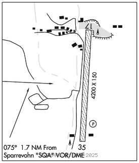
SPARREVOHN LRRS (SVW)(PASV) AF 0 S UTC–9(–8DT) N61°05.83′ W155°34.49′
1565 NOTAM FILE PASV Not insp.

RWY 17–35: 4200X150 (GRVL) 4.8% up N
RWY 17: Hill.
RWY 35: REIL. PAPI(P2R)–GA 4.0° TCH 52′. Hill.
MILITARY REMARKS: CLOSED to the pub; OFFL BUS ONLY. Attended Mon–Fri 1700–0200Z‡, CLOSED hols. PPR all ops; mnm 1 hr prior to dep for site and no earlier than day travel – D317–552–1244/1157/C907–552–1244/1157. Paxmust coord bfr non emerg travel to site D317–552–4935/1089/C907–552–4935/1089. USAF fac; civ acft lndg pmt rqrd bfr arr; pmt rqrd on board; violators fined and rprt to FAA FSDOS IAW 32CFR855 and USAF oprg instrns – D317–552–5282/C907–552–5282 mail attn: 11 AF amgr 10471 20th St Suite 218, Elmendorf AFB, AK 99506. Mts all quads; rwy on slp of 3200′ mt. Apch fm S; lnd Rwy 35 only; tkof Rwy 17 only; dalgt ops only. Successful go around improbable. Rwy 17 and Rwy 35, 4 ft orange mkrs–thr mrd on rwy end. Gtr than 20 kt wind/25 kt radome wind may produce svr turb; radome wind not always avbl. Rwy 17–35 60′ ovrn S end. Aft initial rdo ctc on 126.2 or 121.5 exp 30 min dla for cond rprt.
AIRPORT MANAGER: 907-552-4400
WEATHER DATA SOURCES: AWOS–3 (907) 731–9001 ext 229.
COMMUNICATIONS: CTAF 126.2
RCO 122.5 (KENAI RADIO)
®ANCHORAGE CENTER APP/DEP CON 134.3 351.8
RADIO AIDS TO NAVIGATION: NOTAM FILE SVW.
(H) (H) VORW/DME 117.2 SQA Chan 119 N61°05.91′ W155°38.07′ 075° 1.7 NM to fld. 2501/18E.
VOR & DME unusable:
009°–019°
029°–039° byd 25 NM blo 12,500′
DME portion unusable:
019°–028° byd 16 NM
VOR portion unusable:
019°–029° byd 16 NM
CAIRN MOUNTAIN NDB (HW) 281 CRN N61°06.11′ W155°34.12′ at fld. 1737/15E. NDB has no standby transmitter, May be shutdown without prior notice
COMM/NAV/WEATHER REMARKS: For a toll free call to Kenai FSS dial 1–866–864–1737.