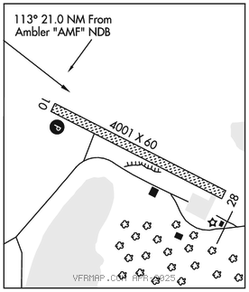
SHUNGNAK (SHG)(PAGH) 0 NW UTC–9(–8DT) N66°53.29′ W157°09.75′
205 B NOTAM FILE SHG

RWY 10–28: 4001X60 (GRVL) MIRL
RWY 10: PAPI(P4R)–GA 3.0° TCH 35′. Brush.
RWY 28: Brush.
SERVICE: LGT ACTIVATE PAPI Rwy 10; MIRL Rwy 10–28–CTAF.
AIRPORTREMARKS: Unattended. Cold temperature airport. Altitude correction required at or below–35C. Rwy condition not monitored; recommend visual inspection prior to ldg. Rwy 10 slopes uphill before apron entry. Rwy 10–28 water ponds or puddles on sfc when wet. Rwy 10–28 marked with lgts and plastic markers.
AIRPORT MANAGER: 907-442-3147
WEATHER DATA SOURCES: AWOS–3P 118.525 (907) 437–2024. (WX CAM)
COMMUNICATIONS: CTAF 122.7
AMBLER RCO 122.0 (KOTZEBUE RADIO)
®ANCHORAGE CENTER APP/DEP CON 119.2
RADIO AIDS TO NAVIGATION: NOTAM FILE OTZ.
KOTZEBUE (H) (H) VORW/DME 115.7 OTZ Chan 104 N66°53.14′ W162°32.40′ 072° 127.2 NM to fld. 121/15E.
AMBLER NDB (HW) 403 AMF N67°06.31′ W157°51.61′ 113° 21.0 NM to fld. 258/15E. NOTAM FILE AFM.
COMM/NAV/WEATHER REMARKS: For LC to Kotzebue FSS dial 907–442–3310. For a toll free call to Kotzebue FSS dial 1–800–478–7460. For a toll free call to Fairbanks FSS dial 1–866–248–6516.