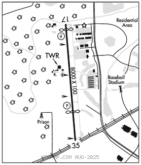
SUGAR LAND RGNL (SGR)(KSGR) P 17 SW UTC–6(–5DT) N29°37.33′ W95°39.39′
81 B NOTAM FILE SGR

RWY 17–35: H8000X100 (CONC) S–80, D–120, 2S–152, 2D–200, 2D/2D2–600 HIRL
RWY 17: REIL. PAPI(P2R)–GA 3.5° TCH 52′. Thld dsplcd 380′. Trees.
RWY 35: REIL. PAPI(P4L)–GA 3.0° TCH 56′. Thld dsplcd 1984′. P–line.
SERVICE: S4 FUEL 100LL, JET A+ OX 1, 2 LGT When ATCT clsd actvt REIL Rwy 17 and 35; HIRL Rwy 17–35–CTAF.
NOISE: Noise abatement proc: Noise sensitive areas–info avbl at trml.
AIRPORT REMARKS: Attended 1100–0500Z‡. Birds on and invof arpt. 100LL avbl 24 hrs self serve. For Jet A+ aft hrs call 281–275–2400 durg atndd hrs. Sfc conds not rprtd 0400–1600Z‡. Rwy 17–35 surface not grvd. Nitrogen avbl dur business hrs. No tgls aft twr closes. No int deps for multi–engine acft. Ramp fee for civ acft waived with fuel purchase. Mil and corporate gnd transportation prvdd. LRA M–F 1400–1800Z‡ & 1900–2300Z‡. Otr times by appt. Ldg fee.
AIRPORT MANAGER: 281-275-2100
WEATHER DATA SOURCES: ASOS 118.125 (281) 242–7605.
COMMUNICATIONS: CTAF 118.65 ATIS 118.125 UNICOM 122.95
®HOUSTON APP/DEP CON 123.8
SUGAR LAND TOWER 118.65 (1200–0400Z‡)
GND CON 121.4 CLNC DEL 121.4 CLNC DEL 119.25 (When twr clsd)
CLEARANCE DELIVERY PHONE: For CD when ATCT is clsd ctc Houston Apch at 281-443-5844 to cnl IFR at 281-443-5888.
AIRSPACE: CLASS D svc 1200–0400Z‡; other times CLASS E.
RADIO AIDS TO NAVIGATION: NOTAM FILE ELA.
EAGLE LAKE (DH) DME 116.4 ELA Chan 111 N29°39.75′ W96°19.03′ 094° 34.6 NM to fld. 192.
ILS/DME 110.7 I–TXH Chan 44 Rwy 35. Class IT.