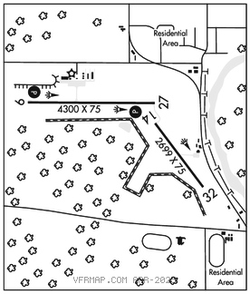
BIG RAPIDS
ROBEN–HOOD (RQB)(KRQB) 2 NW UTC–5(–4DT) N43°43.36′ W85°30.24′ 990 B NOTAM FILE RQB

RWY 09–27: H4300X75 (ASPH–PFC) S–62, D–87 PCN 20 F/A/Y/T MIRL 1.0% up W
RWY 09: REIL. PAPI(P2L)–GA 3.33° TCH 25′.
RWY 27: REIL. PAPI(P4L)–GA 3.08° TCH 25′.
RWY 14–32: H2699X75 (ASPH) S–37, D–56 PCN 10 F/A/Y/T MIRL 0.3% up NW
SERVICE: S4 FUEL 100LL, JET A+ ACTIVATE REIL Rwy 09 and Rwy 27, PAPI Rwy 09 and Rwy 27, MIRL Rwy 09–27 and Rwy 14–32–CTAF. PAPI Rwy 09 unusbl byd 5° right of cntrln.
AIRPORTREMARKS:Attended Mon–Fri 1300–2200Z‡, Sat 1300–2000Z‡. Birds and deer on and invof arpt. 100LL avbl H24 self svc. Single point and overwing Jet A+ avbl. Admin bldg aces: Press 5, then 3 and 2 simul, then 1. Lndg fee for bus and corporate acft, waived with min fuel purchase.
AIRPORT MANAGER: 231-796-5600
WEATHER DATA SOURCES: AWOS–3P 125.875 (231) 796–0884.
COMMUNICATIONS: CTAF/UNICOM 122.8
®MINNEAPOLIS CENTER APP/DEP CON 120.85
CLEARANCE DELIVERY PHONE: For CD ctc Minneapolis ARTCC at 651-463-5588.
RADIO AIDS TO NAVIGATION: NOTAM FILE MOP.
MOUNT PLEASANT (L) (L) VORW/DME 110.6 MOP Chan 43 N43°37.37′ W84°44.24′ 285° 33.9 NM to fld. 752/5W.
DME unusable:
Byd 33 NM blo 4,000′