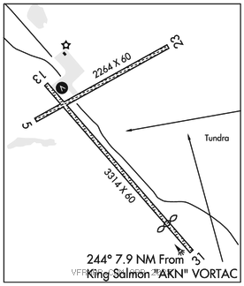
SOUTH NAKNEK NR 2 (WSN)(PFWS) 1 SSW UTC–9(–8DT) N58°42.13′ W157°00.16′
162 B NOTAM FILE WSN

RWY 13–31: 3314X60 (GRVL–DIRT) HIRL
RWY 13: VASI(V2L)–GA 3.0° TCH 25′. Brush.
RWY 31: Thld dsplcd 559′. Brush.
RWY 05–23: 2264X60 (GRVL–DIRT) HIRL 1.5% up SW
RWY 05: Brush.
RWY 23: Brush.
SERVICE: LGT ACTVT VASI Rwy 13; HIRL Rwy 05–23 and 13–31–CTAF.
AIRPORT REMARKS: Unattended. Rwy cond unmnt, rcmnd visual insp prior to use. Vehicles, moose and bears on and invof rwys. Hvy tfc btn S Naknek and Naknek arpts less than two mi apart. Twy slps downhill to NW; no line of sight btn end of twy and Rwy 13–31. Rwy 31 marked short cones and lights.
AIRPORT MANAGER: 907-246-3325
WEATHER DATA SOURCES: AWOS–3P 121.575 (907) 868–7348. (WX CAM)
COMMUNICATIONS: CTAF 122.9
®ANCHORAGE CENTER APP/DEP CON 124.8
RADIO AIDS TO NAVIGATION: NOTAM FILE AKN.
KING SALMON (H) (H) VORTACW 112.8 AKN Chan 75 N58°43.48′ W156°45.14′ 244° 7.9 NM to fld. 95/16E. TACAN antenna offset 150′ se
TACAN AZIMUTH unusable:
130°–140° byd 13 NM blo 4,000′
130°–140° byd 30 NM
332°–348° byd 19 NM blo 5,000′
DME unusable:
332°–348° byd 19 NM blo 5,000′
COMM/NAV/WEATHER REMARKS: For a toll free call to Kenai FSS dial 1–866–864–1737.