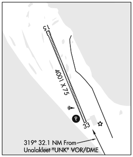
SHAKTOOLIK (2C7)(PFSH) 1 NW UTC–9(–8DT) N64°22.27′ W161°13.44′
24 B NOTAM FILE 2C7

RWY 15–33: 4001X75 (GRVL) MIRL
RWY 33: REIL. PAPI(P4L)–GA 3.0° TCH 25′.
SERVICE: LGT ACTIVATE REIL Rwy 33, PAPI Rwy 33, MIRL Rwy 15–33 –CTAF.
AIRPORT REMARKS: Unattended. Be Alert: old abandoned rwy not marked clsd. Rwy cond not monitored, recommend visual inspection prior to ldg. Rwy 15–33 water ponding and sfc, slippery when wet. Rwy 15–33 marked with lgts and cones.
AIRPORT MANAGER: (907) 625-1025
WEATHER DATA SOURCES: AWOS–3P 124.175 (907) 955–3896. (WX CAM)
COMMUNICATIONS: CTAF/UNICOM 122.8
UNALAKLEET RCO 122.30 (NOME RADIO)
®ANCHORAGE CENTER APP/DEP CON 135.7
RADIO AIDS TO NAVIGATION: NOTAM FILE UNK.
UNALAKLEET (H)(H)VORW/DME 116.9 UNK Chan 116 N63°53.52′ W160°41.06′ 319° 32.1 NM to fld. 436/15E.
COMM/NAV/WEATHER REMARKS: For a toll free call to Nome FSS dial 1–800–478–8400. For a lcl call to Nome FSS dial 443–2291. CTAF 122.8 monitored by local airline agents during daylight hours, no response to non–scheduled aircraft.