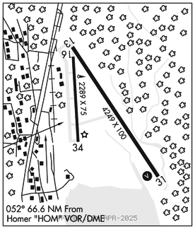
SEWARD (SWD)(PAWD) 2 NE UTC–9(–8DT) N60°07.79′ W149°25.00′
28 B TPA–See Remarks NOTAM FILE SWD

RWY 13–31: H4249X100 (ASPH) MIRL
RWY 13: Bridge.
RWY 31: VASI(V4L)–GA 3.0° TCH 26′. Brush.
RWY 16–34: H2289X75 (ASPH) 0.3% up N
RWY 16: Trees.
SERVICE: FUEL 100LL, JET A LGT ACTVT VASI Rwy 31; MIRL Rwy 13–31–CTAF. Rwy 31 VASI unusbl byd 5 deg right of cntrln; offset 5 deg clkws fm cntrln. Rwy 31 VASI unusbl byd 3 NM; obstn clnc byd 3 NM NA.
AIRPORT REMARKS: Unattended. Rcmd visual insp prior to tkoff or lndg; mntnd on ireg basis. Birds wi 10 NM Spring–Fall. Fixed wing ops ovr 12,500 lb NA. Rwy 16–34 durg winter 4 in dip 15 in wide fm north thr. Hvy acft rstrd to N twy and N 400 ft of apron. Rcmdd proc in efct 1 May–15 Sep to avoid seasonal use heli 1 NM SSW. TPA–fixed wing 1000 ft AGL. Rwys 31 and 34 arrivals maintain at least 800 ft AGL until turning final. Rwys 13 and 16 departures climb straight ahead to at least 800 ft AGL before turning westbound. Cold temperature airport. Altitude correction required at or below –4C.
AIRPORT MANAGER: 907-262-1187
WEATHER DATA SOURCES: ASOS 135.2 (907) 224–2440. (WX CAM)
COMMUNICATIONS: CTAF 122.9
RCO 122.6 (KENAI RADIO)
RADIO AIDS TO NAVIGATION: NOTAM FILE HOM.
HOMER (H) (H) VORW/DME 114.6 HOM Chan 93 N59°42.57′ W151°27.40′ 052° 66.6 NM to fld. 1626/15E.
COMM/NAV/WEATHER REMARKS: For a toll free call to Kenai FSS dial 1–866–864–1737.