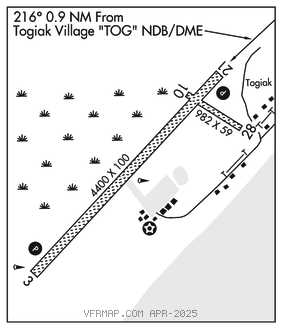
TOGIAK (TOG)(PATG) 0 SW UTC–9(–8DT) N59°03.21′ W160°23.81′
19 B NOTAM FILE TOG

RWY 03–21: 4400X100 (GRVL–DIRT) MIRL
RWY 03: PAPI(P4L)–GA 3.0° TCH 25′. Road.
RWY 21: PAPI(P4L)–GA 3.0° TCH 31′.
RWY 10–28: 982X59 (GRVL)
RWY 28: Bldg.
SERVICE: LGT ACTIVATE PAPI Rwy 03 and Rwy 21, MIRL Rwy 03–21 and rotating bcn–CTAF.
AIRPORT REMARKS: Unattended. RWY COND not monitored, RCMD visual inspection prior to use. Waterfowl invof arpt during migration. Rwy 10–28 thld markers damaged or missing. Segmented circle damaged and overgrown with vegetation.
AIRPORT MANAGER: 907-842-5511
WEATHER DATA SOURCES: AWOS–3P 119.3 (907) 493–5326. (WX CAM)
COMMUNICATIONS: CTAF 122.5
RCO 122.25 (KENAI RADIO)
®ANCHORAGE CENTER APP/DEP CON 132.75
RADIO AIDS TO NAVIGATION: NOTAM FILE TOG.
NDB/DME (HW) 393 TOG Chan 114 N59°03.83′ W160°22.54′ at fld. 11/11E.
DME unusable:
225°–270° byd 32 NM blo 5,700′
271°–359° byd 32 NM blo 6,700′
COMM/NAV/WEATHER REMARKS: For a toll free call to Kenai FSS dial 1–866–864–1737.