SELDOVIA
SELDOVIA (SOV)(PASO) 1 E UTC–9(–8DT) N59°26.63′ W151°42.30′ 29 NOTAM FILE SOV

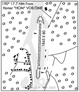
RWY 16–34: 1845X80 (GRVL)
RWY 16: Trees. Rgt tfc.
RWY 34: Tree.
AIRPORT REMARKS: Attended Apr 16–Oct 14 Mon–Thu 1500–0130Z‡, Oct 15–Apr 15 Mon–Fri 1400–2230Z‡. Pilots requested to self announce on CTAF 5 NM from arpt and when taking off and clearing rwy. Snow and ice removal and arpt conditions reporting performed during attendance hrs only. 230 ft safety area for Rwy 34: 500 ft for Rwy 16. Turbulence when wind southeast or southwest. Wind shear on apch to Rwy 16. Ngt ops not authorized. Reflective marking on rwy, end markers both rwy ends. Rwy cond not monitored, recommend visual inspection prior to ldg. Rwy 16 and 34 NSTD mkgs; rwys mkd with cones.
AIRPORT MANAGER: 907-234-7818
WEATHER DATA SOURCES: ASOS 135.4 (907) 234–7407.
COMMUNICATIONS: CTAF 122.9
RADIO AIDS TO NAVIGATION: NOTAM FILE HOM.
HOMER (H) (H) VORW/DME 114.6 HOM Chan 93 N59°42.57′ W151°27.40′ 190° 17.7 NM to fld. 1626/15E.
COMM/NAV/WEATHER REMARKS: For a local call to Homer FSS dial 235–8588. For a toll free call to Kenai FSS dial 1–866–864–1737.