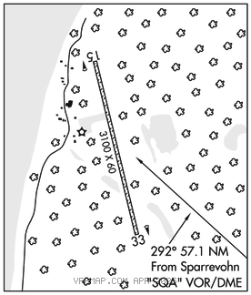
SLEETMUTE (SLQ)(PASL) 0 E UTC–9(–8DT) N61°42.03′ W157°09.95′
192 B NOTAM FILE SLQ

RWY 15–33: 3100X60 (GRVL) MIRL
RWY 15: Brush.
RWY 33: Tree.
SERVICE: FUEL 100LL LGT ACTVT MIRL Rwy 15–33–CTAF.
AIRPORTREMARKS: Unattended. Fuel avbl–CTAF or 907–449–4227. Rwy condition not monitored, recommend visual inspection prior to using. Red Devil Arpt 8 miles NW. ATVs near or on rwy. Rwy 15–33 N 500 ft soft. Rwy 15–33 soft spots on rwy when wet. Rwy 15 and Rwy 33 rwy end marked with lgts. Cold temperature airport. Altitude correction required at or below –36C.
AIRPORT MANAGER: 907-764-5094
WEATHER DATA SOURCES: AWOS–3P 134.85 (907) 449–4226. (WX CAM)
COMMUNICATIONS: CTAF/UNICOM 122.8
ANCHORAGE CENTER APP/DEP CON 128.5
RADIO AIDS TO NAVIGATION: NOTAM FILE SVW.
SPARREVOHN (H) (H) VORW/DME 117.2 SQA Chan 119 N61°05.91′ W155°38.07′ 292° 57.1 NM to fld. 2501/18E.
VOR & DME unusable:
009°–019°
029°–039° byd 25 NM blo 12,500′
DME portion unusable:
019°–028° byd 16 NM
VOR portion unusable:
019°–029° byd 16 NM
COMM/NAV/WEATHER REMARKS: For a toll free call to Kenai FSS dial 1–866–864–1737.