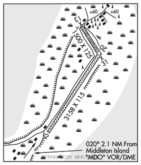
MIDDLETON ISLAND (MDO)(PAMD) 1 S UTC–9(–8DT) N59°27.00′ W146°18.43′
100 NOTAM FILE MDO

RWY 02–20: 3158X115 (GRVL)
RWY 02: Road.
RWY 20: Road.
RWY 13–31: 1500X125 (TURF–DIRT)
RWY 13: Road.
RWY 31: Road.
AIRPORT REMARKS: Unattended. Rwy 13–31 CLOSED indefly. Rwy 13–31 not maintained. Brush 2 ft high Rwy 31 apch. Grass and rocks on rwy. Electrical transformer locate within safety area at the apch end of Rwy 02. BE ALERT: rabbits and waterfowl in rwy area. Eagle nest on apch to Rwy 02. Wx camera located on rwy edge. Rwy 02–20 loose grvl on sfc–rocks to 3". Rwy 02–20 marked with rwy cones. Rwy 13–31 marked with cones and OTS lgts. Many missing. Rwy 02–20 slopes down toward S end. Safety areas soft.
AIRPORT MANAGER: 907-283-4526
WEATHER DATA SOURCES: AWOS–3P 135.725 (907) 424–7635. (WX CAM)
COMMUNICATIONS: CTAF 122.9
RCO 122.05 (JUNEAU RADIO)
®ANCHORAGE CENTER APP/DEP CON 133.6
RADIO AIDS TO NAVIGATION: NOTAM FILE MDO.
(H) (H) VORW/DME 115.3 MDO Chan 100 N59°25.31′ W146°21.00′ 020° 2.1 NM to fld. 133/18E.
COMM/NAV/WEATHER REMARKS: For a toll free call to Juneau FSS dial 1–866–297–2236.