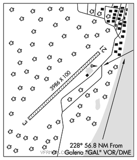
KALTAG (KAL)(PAKV) 1 SW UTC–9(–8DT) N64°19.14′ W158°44.48′
181 NOTAM FILE KAL

RWY 03–21: 3986X100 (GRVL) MIRL 0.3% up SW
RWY 03: Brush.
RWY 21: Road.
SERVICE: LGT ACTIVATE MIRL Rwy 03–21–CTAF.
AIRPORT REMARKS: Unattended. Rwy cond unmnt, rcmd visual insp prior to lndg. Cold temperature airport. Altitude correction required at or below –30C. Snow removal ops–CTAF. Rwy 03–21 surface soft when wet. Rwy 03–21 north 3900′ lgt and mkd with cones.
AIRPORT MANAGER: 907-451-5280
WEATHER DATA SOURCES: AWOS–3 135.25 (907) 534–2272. (WX CAM)
COMMUNICATIONS: CTAF 122.9
®ANCHORAGE CENTER APP/DEP CON 127.0
RADIO AIDS TO NAVIGATION: NOTAM FILE GAL.
GALENA (H) (H) VORW/DME 114.8 GAL Chan 95 N64°44.29′ W156°46.63′ 233° 56.8 NM to fld. 183/12E.
COMM/NAV/WEATHER REMARKS: For a toll free call to Fairbanks FSS dial 1–866–248–6516.