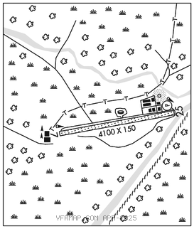
INDIAN MOUNTAIN LRRS (UTO)(PAIM) AF 0 S UTC–9(–8DT) N65°59.57′ W153°42.21′
1261 NOTAM FILE PAIM Not insp.

RWY 07–25: 4100X150 (GRVL)
RWY 07: Pole hill.
RWY 25: REIL. PAPI(P2R)–GA 4.0° TCH 47′. Hill.
SERVICE: LGT REIL Rwy 25; PAPI Rwy 25; opr consly. Rwy 25 PAPI byd 8 degs right of cntrln.
MILITARY REMARKS: CLOSED to the public. OFFL BUS ONLY. Attended Mon–Fri 1700–0200Z‡, CLOSED wkends and fed hol. PPR all ops; mnm 1 hr prior to dep for site and no earlier than day travel – DSN 317–552–3211/4310, C907–552–3211/4310. CAUTION: Wind 20 kts or gtr may produce svr turb. Pax must coord bfr non emerg travel to site – D317–552–4935/1089/C907–552–4935/1089). USAF fac; civ acft lndg pmt rqrd bfr arr; pmt rqrd on board; violators fined and rptd to FAA FSDOS IAW 32CFR855 and USAF oprg instrns – D 317–552–5282/C907–552–5282 or mail attn: 11 AF amgr 10471 20th street Suite 218 Elmendorf, AFB, AK 99506. Land Rwy 25, tkof Rwy 07. Vis lndg zone mkr panels IAW AF IR Instrn 13–217, marking pat –1. Aft initial rdo ctc on 126.2 or 121.5 exp 30 min dla for cond rprt.
AIRPORT MANAGER: 907-552-7610
WEATHER DATA SOURCES: AWOS–3 (907) 552–3211
COMMUNICATIONS: CTAF 126.2
RCO 122.6 (FAIRBANKS RADIO)
®ANCHORAGE CENTER APP/DEP CON 124.6 352.0
RADIO AIDS TO NAVIGATION: NOTAM FILE UTO.
UTOPIA CREEK NDB/DME (HW) 272 UTO Chan 22(Y) N65°59.71′ W153°41.63′ at fld. 983/17E.
NDB unusable:
210°–240°
340°–355°
NDB/DME unusable:
45–105 byd 25 NM
105–45
COMM/NAV/WEATHER REMARKS: For a toll free call to Fairbanks FSS dial 1–866–248–6516.