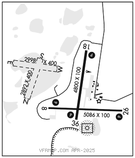
ILIAMNA (ILI)(PAIL) 2 NW UTC–9(–8DT) N59°45.33′ W154°55.07′
192 B NOTAM FILE ILI

RWY 08–26: H5086X100 (ASPH–GRVD) MIRL
RWY 08: PAPI(P4L)–GA 3.0° TCH 35′. Brush.
RWY 26: REIL. PAPI(P4L)–GA 3.0° TCH 35′. Brush.
RWY 18–36: H4800X100 (ASPH–GRVD) MIRL
RWY 18: PAPI(P4L)–GA 3.0° TCH 30′. Brush.
RWY 36: REIL. PAPI(P4L)–GA 3.0° TCH 32′. Brush.
SERVICE: FUEL 100LL, JET A LGT When FSS clsd ACTVT REIL Rwy 26 and 36; PAPI Rwy 18, 36, 08 and 26; MIRL Rwy 08–26; 18–36–CTAF.
AIRPORT REMARKS: Attended Oct–May Mon–Fri 1700–0130Z‡, Jun–Sep Mon–Wed 1500–0130Z‡, Jun–Sep Thurs 1500–2300Z‡. Psnl and eqpt may be on rwy. BE ALERT: No line of sight btn Iliamna, Pike Lake and East Wind Lake/Strip; tfc pat and VFR arr and dep proc see Section C Notice. Snow and ice removal and haz rprtng durg duty hr; exc PPR in writing–Amgr. Cold temperature airport. Altitude correction required at or below –26C. Taxi on active rwys; locked brake turns on rwy NA. There are no locked brake turns allowed on rwys. Multiple airstrips and float plane basins invof arpt; low–level hel sling load ops wi 25 NM W–NW; mnt CTAF and self announce upon entry. Safety areas soft. Rwy 08–26 tundra wheel grvl sfc 275 ft prior to asph both end; dalgt ops only. Tsnt prkg mkd with green cones. Arpt sand lrgr than FAA rcmdd/see AC1505200–30. NOTE: See Special Notices–Traffic Patterns, Communications and Aircraft Operations.
AIRPORT MANAGER: 907-571-1261
WEATHER DATA SOURCES: ASOS 134.95 (907) 571–1483. ASOS prvdd when Iliamna FSS clsd. (WX CAM)
COMMUNICATIONS: CTAF 123.6 AFIS 134.95 (15 May–15 Oct 1445–0645Z‡; OT ctc Kenai FSS)
FSS ILI (ILIAMNA) 1 Jun–30 Sep 1445–0645Z‡; OT ctc Kenai FSS.
ILIAMNA RADIO 121.5 122.2 123.6 (LAA 123.6)
RCO 121.5 122.2 123.6 (KENAI RADIO)
ANCHORAGE CENTER APP/DEP CON 118.8
AIRSPACE: CLASS E svc 1445–0645Z‡; other times CLASS G.
RADIO AIDS TO NAVIGATION: NOTAM FILE ILI.
NDB/DME (HW) 411 ILI Chan 91 N59°44.88′ W154°54.58′ at fld. 168/14E.
DME unusable:
010°–020° byd 20 NM blo 12,000′
020°–050° byd 25 NM blo 13,000′
270°–300° byd 25 NM blo 7,000′
300°–320° byd 25 NM blo 8,000′
COMM/NAV/WEATHER REMARKS:Iliamna FSS telephone 571–1240. For a toll free call to Kenai FSS, dial 1–866–864–1737. WX obs 16 Oct–14 May 1445–0645Z‡–Iliamna wx 133.75 or 907–571–1240. DME located at 59°45.0′N 154°54.4′W. DME channel 91 paired with VHF freq 114.4. ASOS 134.95 when Iliamna FSS closed. AFIS operd by ILI FSS when open, OT Kenai FSS. • • • • • • • • • • • • • • • • • •
WATERWAY E–W: 2998X400 (WATER)
WATERWAY N–S: 2892X400 (WATER)
WATERWAY S: Rgt tfc.