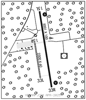
GULKANA (GKN)(PAGK) 4 NE UTC–9(–8DT) N62°09.26′ W145°27.32′
1586 B NOTAM FILE GKN

RWY 15L–33R: H5001X100 (ASPH) MIRL
RWY 15L: VASI(V4L)–GA 3.0° TCH 49′. Trees.
RWY 33R: VASI(V4R)–GA 3.0° TCH 29′. Trees.
RWY 15R–33L: 2300X60 (GRVL)
RWY 15R: Tower.
RWY 33L: Trees.
SERVICE: S2 FUEL 100LL, JET A LGT ACTVT VASI Rwy 15L and Rwy 33R; MIRL Rwy 15L–33R–CTAF.
AIRPORT REMARKS: Attended Jun–Sep Mon–Fri 1800–0200Z‡, Oct–May Mon–Fri 1900–0000Z‡. Fuel avbl 24 hours with credit card or call 907–822–4331. Arpt located 4 SM NE of Glennallen. Moose and Caribou on and around arpt. Migratory birds on and in vcnty of arpt dur spring. Personnel and equipment may be working on rwy at any time. Rwy condition not monitored; recommend visual inspection prior to landing. Rwy 15R–33L is maintained as ski strip in winter and grvl strip the remainder of the year. Visual inspection reqd before lndg. Beacon twr and other obstacles on N apch end. Airframe/powerplant svc covers small single/twin propeller engine acft less than 12500 lbs.
AIRPORT MANAGER: 907-822-3222
WEATHER DATA SOURCES: ASOS 134.85 (907) 822–3707. (WX CAM)
COMMUNICATIONS: CTAF 122.9
RCO 122.2 (KENAI RADIO)
ANCHORAGE CENTER APP/DEP CON 119.5
SUAIS 125.3 126.3 (1–800–758–8723).
AIRSPACE: CLASS E svc 1500–0630Z‡; other times CLASS G.
RADIO AIDS TO NAVIGATION: NOTAM FILE GKN.
(H) (H) VORW/DME 115.6 GKN Chan 103 N62°09.23′ W145°26.84′ at fld. 1549/17E.
COMM/NAV/WEATHER REMARKS: For a toll free call to Kenai FSS dial 1–866–864–1737.