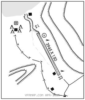
CAPE NEWENHAM LRRS (EHM)(PAEH) AF 1 SE UTC–9(–8DT) N58°38.89′ W162°03.83′
531 NOTAM FILE PAEH Not insp.

RWY 15–33: 3945X150 (GRVL) 7.7% up SE
RWY 15: REIL. PAPI(P2L)–GA 3.0° TCH 44′.
RWY 33: Mtn.
SERVICE: LGT RDO req on 126.2.
MILITARY REMARKS: OFFL BUS ONLY; CLOSED to the pub. Attended dalgt hrs. Afld is clsd wkends and all fed hol. Arr 24 hr PPR and no ltr than 1 hr prior to dep–D317–552–9419/93709370/C907–552–9419/9370. Pax req coord bfr non emerg travel to site – D317–552–4935/1089/C907–552–4935/1089. USAF fac; civ opr must have Civ Acft Lndg Pmt bfr PPR; 30 days prior to lndg – C907–552–5282/D317–552–5282 or mail to attn: 11 AF amgr 10471 20th street Suite 218, JBER, AK 99506. Failure to obtain and have onboard will result in fine and rptd to FAA FSDO and U.S. Attorney′s OFC IAW 32 CFR 855 and USAF operg instr. CTN: Rwy 15–33 on slp of 2305′ mt. high trrn both sides and S end. Successful go–around improbable. Rwy and parking apron on 7.9% grade. Estab rdo ctc on 126.2 or 121.5 asap bfr lndg; exp 30 min dly for fld cond. Rwy 15 last 200′ may have prkd acft.
AIRPORT MANAGER: 907-552-5105
WEATHER DATA SOURCES: AWOS–3 (907) 552–9419 additional number 907–552–9370 ext 8.
COMMUNICATIONS: CTAF 126.2
RCO 122.3 (KENAI RADIO)
®ANCHORAGE CENTER APP/DEP CON 124.2 251.1
RADIO AIDS TO NAVIGATION: NOTAM FILE EHM.
NDB/DME (HW) 385 EHM Chan 18(Y) N58°39.36′ W162°04.42′ at fld. 212/12E. NDB has no standby transmitter
DME portion unusable:
050°–169° byd 10 NM blo 7,000′
170°–224°
225°–293° byd 10 NM blo 7,000′
294°–320° byd 30 NM
COMM/NAV/WEATHER REMARKS: For a toll free call to Kenai FSS dial 1–800–864–1737. DME channel 18(Y) paired with VHF freq 108.15.