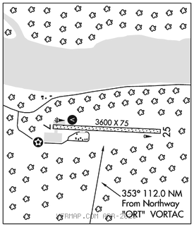
EAGLE (EAA)(PAEG) 2 E UTC–9(–8DT) N64°46.69′ W141°08.98′
907 B NOTAM FILE EAA

RWY 07–25: 3600X75 (GRVL) MIRL
RWY 07: VASI(V4L)–GA 3.75° TCH 39′. Hill.
RWY 25: Trees.
SERVICE: LGT ACTIVATE MIRL Rwy 07–25, VASI Rwy 07 and rotating bcn–CTAF.
AIRPORT REMARKS: Unattended. Rwy cond not monitored, recommend visual inspection prior to ldg. 100LL and Jet A avbl by calling 907–547–2220. Helicopter ops from south ramp dur summer months. Rwys 07 and 25 marked with reflective thld panels and cones. Report on arr. Cstms unavbl ctc 907–774–2252 for info. Cold temperature airport. Altitude correction required at or below –12C.
AIRPORT MANAGER: 907-883-5128
WEATHER DATA SOURCES: ASOS 135.55 (907) 547–2351. (WX CAM)
COMMUNICATIONS: CTAF/UNICOM 122.8
RCO 122.3 (NORTHWAY RADIO)
®ANCHORAGE CENTER APP/DEP CON 135.3
SUAIS 125.3 126.3 (1–800–758–8723).
RADIO AIDS TO NAVIGATION: NOTAM FILE ORT.
NORTHWAY (H) (H) VORTACW 116.3 ORT Chan 110 N62°56.83′ W141°54.76′ 353° 112.0 NM to fld. 1779/17E.
TACAN AZIMUTH unusable:
342°–037° byd 30 NM blo 10,500′
DME unusable:
342°–037° byd 30 NM blo 10,500′
COMM/NAV/WEATHER REMARKS: For a toll free call to Northway FSS dial 1–800–478–6611. For a toll free call to Fairbanks FSS dial 1–866–248–6516.