SCAMMON BAY (SCM)(PACM) 0 N UTC–9(–8DT) N61°50.67′ W165°34.43′
22 B NOTAM FILE SCM
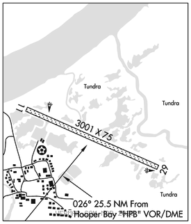
RWY 11–29: 3001X75 (DIRT) MIRL
RWY 29: Brush. Rgt tfc.
SERVICE: LGT ACTVT MIRL Rwy 11–29–CTAF.
AIRPORT REMARKS: Unattended. Rwy condition unmnt, rcmd visual insp prior to use. Psbl gusty crosswind. Birds on rwy. Cold temperature airport. Altitude correction required at or below –20C. Road used to cross rwy to river. Rwy 11–29 soft durg spring breakup, after rain and high tide. Rwy 11–29 edges soft and sloughing twd tundra, Road Xs rwy. Rwy 29 safety area soft and contains lrg rock; only 75 ft usbl. Wind indicators unreliable. Rwy 29 mkd with cones and reflective thr panels. Rwy 11 cones and thr panels, panels damaged or missing.
AIRPORT MANAGER: 907-543-2498
WEATHER DATA SOURCES: AWOS–3P 118.425 (907) 600–3004. (WX CAM)
COMMUNICATIONS: CTAF/UNICOM 123.0
®ANCHORAGE CENTER APP/DEP CON 124.5
RADIO AIDS TO NAVIGATION: NOTAM FILE HPB.
HOOPER BAY (H) (H)VORW/DME 115.2 HPB Chan 99 N61°30.86′ W166°08.07′ 026° 25.5 NM to fld. 15/13E.
VOR unusable:
358°–013° byd 22 NM blo 3,500′
DME unusable:
358°–013° byd 22 NM blo 3,500′
COMM/NAV/WEATHER REMARKS: For a toll free call to Kenai FSS dial 1–866–864–1737.