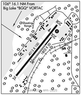
BIRCHWOOD (BCV)(PABV) 2 NW UTC–9(–8DT) N61°24.97′ W149°30.50′
83 B NOTAM FILE BCV

RWY 02L–20R: H4012X100 (ASPH) MIRL 0.4% up S
RWY 02L: Trees.
RWY 20R: VASI(V4L). TCH 48′. Trees. Rgt tfc.
RWY 02R–20L: H1802X50 (ASPH–GRVL) 0.3% up S
RWY 20L: Rgt tfc.
SERVICE: S4 FUEL 100LL LGT ACTVT VASI Rwy 20R; MIRL Rwy 02L–20R–CTAF. ACTVT VASI Rwy 20R –7 clicks.
AIRPORTREMARKS: Unattended. Winter maint na. Rwy cond unmnt; rcmnd vis inspn bfr lndg. CTN: Sailplane ops. Hel avoid fixed wing and ultralight tfc pat. Rwy 02R–20L 600 ft asph on Rwy 20L end, rmndr grvl. Mid 1500 ft of Twy A dsgnd ultralight and ski/tundra tire equip rwy; parl ops na–seq on CTAF. Rwy 20L and Rwy 20R, rgt tfc, exc ultralight; use L tfc E away fm rwys. Rwy 02R–20L ski/tundra tire rwy. Tsnt prkg avbl; fee aft 24 hr.
AIRPORT MANAGER: 907-338-1466
WEATHER DATA SOURCES: AWOS–3P 135.55 (907) 621–7605. (WX CAM)
COMMUNICATIONS: CTAF 123.0
RCO 122.3 122.55 (KENAI RADIO)
RADIO AIDS TO NAVIGATION: NOTAM FILE ENA.
BIG LAKE (H) (H) VORTACW 112.5 BGQ Chan 72 N61°34.17′ W149°58.03′ 106° 16.1 NM to fld. 179/19E.
TACAN AZIMUTH unusable:
230°–245° byd 38 blo 8,000′
DME unusable:
230°–245° byd 38 blo 8,000′
COMM/NAV/WEATHER REMARKS: For a toll free call to Kenai FSS dial 1–866–864–1737.