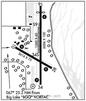
WARREN "BUD" WOODS PALMER MUNI (PAQ)(PAAQ) 1 SE UTC–9(–8DT) N61°35.70′
W149°05.32′ 249 B NOTAM FILE PAQ

RWY 16–34: H6006X100 (ASPH) S–180 PCN 34 F/B/X/U MIRL 0.5% up N
RWY 16: REIL. PAPI(P4L)–GA 3.0° TCH 43′. Thld dsplcd 503′. Trees.
RWY 34: REIL. PAPI(P4L)–GA 3.0° TCH 52′. Trees.
RWY 10–28: H3616X75 (ASPH) PCN 7 R/B/X/U MIRL
RWY 10: PAPI(P2L)–GA 3.0° TCH 27′. Road.
RWY 28: PAPI(P2L)–GA 3.0° TCH 26′. Hill.
RWY 16S–34S: 1560X60 (GRVL) 0.5% up N
RUNWAY DECLARED DISTANCE INFORMATION
RWY 16: TORA–6008 TODA–6008 ASDA–6008 LDA–5508
RWY 34: TORA–6008 TODA–6008 ASDA–6008 LDA–6008
SERVICE: S4 FUEL 100LL, JET A1 LGT When FSS clsd actvt REIL Rwy 16 and 34; PAPI Rwy 10, 28, 16 and 34; MIRL Rwy 16–34 and Rwy 10–28–CTAF. PAPI Rwy 28 unusbl byd 3.0 NM; does not prvd obstn clnc byd 3 NM fm thr. PAPI Rwy 34 unusbl byd 5.4 NM; does not prvd obstn clnc byd 5.4 NM fm thr.
AIRPORT REMARKS: Attended 1700–0200Z‡ Mon–Fri. Parachute Jumping. Waterfowl and birds on arpt; spcly spring and fall. Sky diving and glider act on and invof arpt Apr–Sep; Banner towing ops May–Oct Thu–Sun. Rwy cond avbl 1900Z‡ Mon–Fri; wkend and hol NA. Rwy 10–28 CLOSED to acft over 12,500 lb. A1: Fuel avbl N and S ramp H24 with credit card. Rwy 16S–34S avbl W side and parl to Rwy 16–34; simul parl ops NA; thr and edge mkd with cones; winter maint NA; seq–CTAF. Rwy 10, 7 ft fence 435 ft W of thld. Winter maintenance not avbl. Tsnt prkg N ramp spaces T1–T9 adj FSS: lrg acft tsnt prkg S ramp spaces T10, T11, and T12. Fire tanker base N end; mult lrg acft flts act May–Sep; use dsgnd runup area and give way to emerg acft; info–FSS 907–745–2495 or 122.4.
AIRPORT MANAGER: 907-761-1334
WEATHER DATA SOURCES: ASOS 134.75 (907) 746–6675. (WX CAM)
COMMUNICATIONS: CTAF 123.6 AFIS 134.75
FSS PAQ (PALMER) 134.75 1700–0300Z‡ OT ctc Kenai FSS.
PALMER RADIO 122.4 123.6 (LAA 123.6)
RCO 122.4 123.6 (KENAI RADIO)
®ANCHORAGE APP/DEP CON 118.6 290.5
RADIO AIDS TO NAVIGATION: NOTAM FILE ENA.
BIG LAKE (H) (H) VORTACW 112.5 BGQ Chan 72 N61°34.17′ W149°58.03′ 067° 25.2 NM to fld. 179/19E.
TACAN AZIMUTH unusable:
230°–245° byd 38 blo 8,000′
DME unusable:
230°–245° byd 38 blo 8,000′
COMM/NAV/WEATHER REMARKS: For a local call to Palmer FSS dial 745–2495. AFIS avbl on 134.75. AFIS operd by Palmer FSS when open. • • • • • • • • • • • • • • • • • •
HELIPAD H1: H50X50 (ASPH)