MOUNT PLEASANT RGNL (OSA)(KOSA) 3 S UTC–6(–5DT) N33°05.81′ W94°57.71′
364 B NOTAM FILE OSA
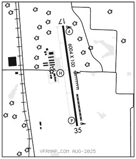
RWY 17–35: H6004X100 (ASPH) S–30 MIRL 0.4% up N
RWY 17: REIL. PAPI(P4L)–GA 3.0° TCH 40′.
RWY 35: REIL. PAPI(P4L)–GA 3.0° TCH 45′. Trees.
SERVICE: S4 FUEL 100LL, JET A LGT REIL Rwy 17 and 35, MIRL Rwy 17–35 pre–set on low SS–SR. To actvt daytime and incr intst–CTAF. PAPI Rwy 17 and 35 opr consly.
AIRPORT REMARKS: Attended 1300–0000Z‡. Deer and wildlife on and invof arpt. For Jet A aft hrs call 903–575–4004. 100LL avbl 24 hrs self serv. No line of sight between rwy ends. Rwy 17 and Rwy 35 mkgs discolored.
AIRPORT MANAGER: 903-575-4020
WEATHER DATA SOURCES: AWOS–3 119.775 (903) 575–4027.
COMMUNICATIONS: CTAF/UNICOM 122.7
®FORT WORTH CENTER APP/DEP CON 132.025
CLEARANCE DELIVERY PHONE: For CD ctc Fort Worth ARTCC at 817-858-7584.
RADIO AIDS TO NAVIGATION: NOTAM FILE FTW.
QUITMAN (L) DME 114.0 UIM Chan 87 N32°52.83′ W95°22.01′ 058° 24.2 NM to fld. 517. • • • • • • • • • • • • • • • • • •
HELIPAD H1: H44X44 (CONC)
HELIPORT REMARKS: H1 mkgs discolored.