OPELOUSAS
ST LANDRY PARISH (OPL)(KOPL) 2 NW UTC–6(–5DT) N30°33.50′ W92°05.96′ 74 B NOTAM FILE OPL

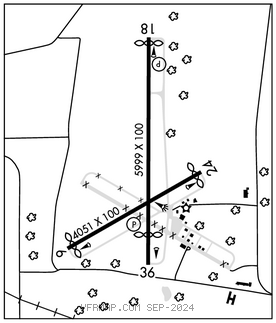
RWY 18–36: H5999X100 (CONC) S–30 MIRL
RWY 18: REIL. PAPI(P2L)–GA 3.5° TCH 58′. Thld dsplcd 150′. Tree. Rgt tfc.
RWY 36: REIL. PAPI(P2L)–GA 3.5° TCH 59′. Thld dsplcd 789′. Road.
RWY 06–24: H4051X100 (CONC) S–30
RWY 06: Thld dsplcd 165′. Trees.
RWY 24: Thld dsplcd 169′. Trees. Rgt tfc.
SERVICE: S2 FUEL 100LL, JET A+ LGT REIL Rwy 18 & 36; MIRL Rwy 18–36, preset low intst dusk–dawn; to incr intst ACTVT–CTAF.
AIRPORT REMARKS: Attended Mon–Fri 1400–2230Z‡, Sat 1400–1800Z‡. Parachute Jumping. Ctc aprt mgr for acceptable forms of payment for fuel. Rwy 06–24 markings are faded. Rwy 06–24 has some cracks with grass growing thru cracks. Rwy end 06: Rwy markings are faded. Rwy end 24: Rwy markings are faded.
AIRPORT MANAGER: 337-407-1551
WEATHER DATA SOURCES: AWOS–3PT 118.775 (337) 948–8560.
COMMUNICATIONS: CTAF/UNICOM 123.0
®LAFAYETTE APP/DEP CON 128.7 (1130–0430Z‡)
HOUSTON CENTER APP/DEP CON 126.35 (0430–1130Z‡)
CLEARANCE DELIVERY PHONE: For CD ctc Lafayette Apch at 337-262-2729, when Apch clsd ctc Houston ARTCC at 281-230-5622.
RADIO AIDS TO NAVIGATION: NOTAM FILE LFT.
LAFAYETTE (L) (L) VORTACW 109.8 LFT Chan 35 N30°11.63′ W91°59.55′ 343° 22.5 NM to fld. 36/3E.
TACAN AZIMUTH unusable:
295°–320° blo 4,000′