NOME
NOME (OME)(PAOM) 2 W UTC–9(–8DT) N64°30.75′ W165°26.66′ 41 B TPA–See Remarks LRA ARFF Index–See Remarks NOTAM FILE OME

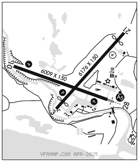
RWY 03–21: H6176X150 (ASPH–GRVD) S–120, D–250, 2D–550 PCR 719 F/A/X/T MIRL 0.4% up NE
RWY 03: REIL. PAPI(P4L)–GA 3.0° TCH 29′. Thld dsplcd 600′. Road.
RWY 21: PAPI(P4L)–GA 3.0° TCH 32′. Thld dsplcd 601′. Pole.
RWY 10–28: H6009X150 (ASPH–GRVD) S–150, D–250, 2D–550 PCR 719 F/A/X/T HIRL
RWY 10: REIL. PAPI(P4L)–GA 3.0° TCH 38′. RVR–R Hill.
RWY 28: MALSR. PAPI(P4L)–GA 3.0° TCH 51′. RVR–T Hill.
RUNWAY DECLARED DISTANCE INFORMATION
RWY 03: TORA–6176 TODA–6176 ASDA–6176 LDA–5576
RWY 10: TORA–6009 TODA–6009 ASDA–6009 LDA–6009
RWY 21: TORA–5576 TODA–5576 ASDA–5576 LDA–5576
RWY 28: TORA–6009 TODA–6009 ASDA–6009 LDA–6009
ARRESTING GEAR/SYSTEM
RWY 28: EMAS
SERVICE: S2 FUEL 100LL, JET A, A1+ LGT ACTVT MALSR Rwy 28; REIL Rwy 03 and 10; PAPI Rwy 03, 10, and 28; HIRL Rwy 10–28; MIRL Rwy 03–21–CTAF. Rwy 21 PAPI opr consly. PAPI unusbl byd 2 NM fm thr due to rapidly rising terrain. Rwy 03–21 and Rwy 10–28 edge intens rwy lgts 30 in abv gnd.
AIRPORTREMARKS:Attended 1600–0330Z‡. Birds invof arpt Sep–Oct and May–Jun. Class I, ARFF Index B. ARFF svc durg acr ops only; acr ops more than 30 pax seats PPR in writing– AMGR PO Box 1048, Nome AK 99762. Numerous wind turbine twrs 820′ MSL (130′ AGL) 4 NM NNW lgtd. Rwy 21 and 28 maintain TPA until final. 100LL hrs vrb–aft hr AMGR. Airfield maint svcs avbl 1600–1730Z‡; aft hr–AMGR. (ANG) Aviation Operating Facility–ANG Hngr 907–387–1800. Ops 1700–0100Z‡; ltd maintenance and svcs avbl. Arpt sand larger gradation than FAA recommended/see AC150/5200–30. Rwy 03 apch slope 26:1 due to 35 ft road 1128 ft from dthr. Rwy 21 apch slope 34:1 due to 69 ft pole 1550 ft from dthr. TSA reg; see 49 CFR 1542. Gates and doors must be secured H24. Info–AMGR. Transient or unfamiliar pilots contact airport manager with questions.
AIRPORT MANAGER: 907-443-2500
WEATHER DATA SOURCES: ASOS 119.925 (907) 443–4818. (WX CAM)
COMMUNICATIONS: CTAF 123.6 AFIS 119.925 (1615–0745Z‡; OT ctc Fairbanks FSS)
FSS OME (NOME) 1615–0745Z‡; OT ctc Fairbanks FSS.
NOME RADIO 121.5 122.2 122.45 123.6 243.0 (LAA 123.6)
ANCHORAGE CENTER APP/DEP CON 133.3 290.4
AIRSPACE: CLASS E svc continuous.
RADIO AIDS TO NAVIGATION: NOTAM FILE OME.
(H) (H) VORW/DME 115.0 OME Chan 97 N64°29.11′ W165°15.19′ 278° 5.2 NM to fld. 95/11E.
FORT DAVIS NDB (HW) 529 FDV N64°29.68′ W165°18.91′ 277° 3.5 NM to fld. 117/11E.
ILS/DME 108.7 I–OME Chan 24 Rwy 28. Localizer backcourse unusable within 1.0 DME. DME unmonitored.
COMM/NAV/WEATHER REMARKS: For a LC to Nome FSS dial 907–443–2291. For a toll free call to Nome FSS dial 1–800–478–8400. For a toll free call to Fairbanks FSS dial 1–866–248–6516. AFIS operd by OME FSS when open, OT Fairbanks FSS.