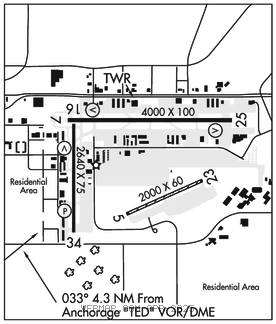
MERRILL FLD (MRI)(PAMR) 2 E UTC–9(–8DT) N61°12.81′ W149°50.68′
143 B TPA–See Remarks LRA NOTAM FILE MRI

RWY 07–25: H4000X100 (ASPH) S–50, D–80 MIRL 0.3% up E
RWY 07: REIL. VASI(V2L)–GA 3.75° TCH 43′. Pole. Rgt tfc.
RWY 25: REIL. VASI(V2L)–GA 3.0° TCH 21′. Bldg.
RWY 16–34: H2640X75 (ASPH) S–20 MIRL 0.3% up N
RWY 16: REIL. VASI(V2R)–GA 3.0° TCH 22′. Bldg. Rgt tfc.
RWY 34: REIL. PAPI(P2L)–GA 3.0° TCH 21′. Bldg.
RWY 05–23: H2000X60 (ASPH–GRVL)
RWY 05: Tree.
RWY 23: Road.
SERVICE: S4 FUEL 100, JET A OX 2, 4 LGT ACTVT REIL Rwy 07, 16, 25, 34; MIRL Rwy 07–25 and 16–34–CTAF. PAPI Rwy 34; VASI Rwy 07, 16 and 25 opr consly. All rwy and twy lgts nonstd height.
NOISE: Noise abatement; TGL or pat work NA 0700–1600Z‡.
AIRPORT REMARKS: Special Air Traffic Rules–Part 93, see Regulatory Notices. Attended Mon–Fri 1630–0230Z‡. Rwy 05–23 first 60 ft paved; rmng grvl. Rwy 05–23 used seasonally as snow rwy. Rcmd ski equip acft use to minimize wheel rutting. Helipad locid 2OK. 1–8 ft snow berms adj to rwys and twys durg winter. Birds and seagulls on and invof arpt. Nonmovement area ctc gnd ctl bfr taxi. Ptns of Twy C btn Twy S and Twy N, and ptns of Twy Q not vis fm twr. Twy B south of Twy M, Twy G btn Twy N and Rwy 05–23, Twy Q east of Twy C and all sfcs south of Rwy 05–23 unctld. PPR ovr 12500 lb. TPA for acft 105 kts or less 900 ft MSL. Acft greater than 105 kts 1200 ft MSL. Compass rose avbl with prior cdn–ATCT. Arr/Dep Routes–See Area Notices; Spl Notice Cartee Asp. Alaska Rgnl Hospital 2OK heli on arpt; See separate listing for info.
AIRPORT MANAGER: 907-343-6301
WEATHER DATA SOURCES: ASOS 124.25 (907) 271–5277. (WX CAM)
COMMUNICATIONS: CTAF 126.0 UNICOM 122.95 ATIS 124.25
RCO 122.2 (KENAI RADIO)
RCO 122.55 122.3 (KENAI RADIO)
®ANCHORAGE APP/DEP CON 363.2 119.1
TOWER 126.0 127.55 (1600–0700Z‡) GND CON 121.7
AIRSPACE: CLASS D svc 1600–0700Z‡l; other times CLASS E..
VOR TEST FACILITY (VOT) 111.0
RADIO AIDS TO NAVIGATION: NOTAM FILE ANC.
ANCHORAGE (H)(H) VORW/DME 113.15 TED Chan 78(Y) N61°10.07′ W149°57.61′ 033° 4.3 NM to fld. 92/18E.
VOR unusable:
041°–091° byd 25 NM blo 15,000′
091°–096° byd 20 NM blo 15,000′
096°–121° byd 25 NM blo 12,500′
121°–146° byd 25 NM blo 9,000′
DME unusable:
041°–091° byd 25 NM blo 15,000′
091°–096° byd 20 NM blo 15,000′
096°–121° byd 25 NM blo 12,500′
121°–146° byd 25 NM blo 9,000′
196°–206° byd 25 NM blo 3,500′
206°–211° byd 25 NM blo 4,000′
211°–221° byd 25 NM blo 3,500′
COMM/NAV/WEATHER REMARKS: For a toll free call to Kenai FSS dial 1–866–864–1737. FM radio interference may be received on twr freqs in tfc patterns. When ATCT clsd ctc Merrill wx–CTAF or 271–4355. When twr clsd CTAF procedures are recommended. See Regulatory Notices Anchorage Terminal Area Merrill Segment this supplement. Use freq 122.55 (BCV RCO) for filing, activating and canceling flight plans in the Anchorage Bowl Area.