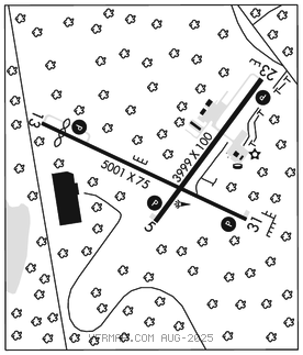
MOUNT POCONO
POCONO MOUNTAINS RGNL (MPO)(KMPO) 2 NW UTC–5(–4DT) N41°08.26′ W75°22.80′ 1915 B NOTAM FILE MPO

RWY 13–31: H5001X75 (ASPH) S–30, D–45 MIRL
RWY 13: REIL. PAPI(P2L)–GA 3.0° TCH 44′. Thld dsplcd 501′. Trees.
RWY 31: REIL. PAPI(P2L)–GA 3.5° TCH 40′. Trees.
RWY 05–23: H3999X100 (ASPH) S–30, D–45, 2D–70 MIRL 1.0% up NE
RWY 05: REIL. PAPI(P2L)–GA 4.0° TCH 43′. Trees.
RWY 23: REIL. PAPI(P2L)–GA 4.0° TCH 53′. Road.
SERVICE: S4 FUEL 100LL, JET A LGT ACTVT REIL Rwy 05, 13, 23 and 31; PAPI Rwy 05 13, 23 and 31; MIRL Rwy 05–23 and 13–31–CTAF.
NOISE: Noise abatement procedures in effect, for details ctc arpt manager at 570–839–0258. Rwy 31 VFR departure: fly heading 310 till crossing Interstate 380, then proceed on course avoiding overflight of homes southwest of Rwy 13–31.
AIRPORTREMARKS: Attended 1200–2200Z‡. Birds, deer and other wildlife on and invof arpt. For svc after hrs call 570–807–8966. 24 hr self svc 100LL avbl.
AIRPORT MANAGER: (570) 839-0258
WEATHER DATA SOURCES: ASOS 120.275 (570) 839–1584.
COMMUNICATIONS: CTAF/UNICOM 122.7
®WILKES–BARRE APP/DEP CON 126.3
CLNC DEL 125.3
RADIO AIDS TO NAVIGATION: NOTAM FILE AVP.
WILKES–BARRE (L)(L) VORTACW 111.6 LVZ Chan 53 N41°16.37′ W75°41.37′ 130° 16.2 NM to fld. 2118/10W.
VOR unusable:
290°–305° byd 15 NM blo 6,000′
COMM/NAV/WEATHER REMARKS: UNICOM 1300Z‡–dusk daily.