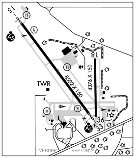
MOBILE RGNL (MOB)(KMOB) P (CG ARNG) 11 W UTC–6(–5DT) N30°41.49′ W88°14.57′
219 B TPA—See Remarks LRA Class I, ARFF Index B NOTAM FILE MOB

RWY 15–33: H8502X150 (ASPH–GRVD) S–75, D–162, 2D–270, 2D/2D2–550 PCN 55 F/D/W/U HIRL
RWY 15: MALSR. PAPI(P4L)—GA 3.0° TCH 50′. RVR–T
RWY 33: MALSR. PAPI(P4L)—GA 3.0° TCH 50′. RVR–T
RWY 18–36: H4376X150 (ASPH–GRVD) S–47, D–60, 2D–96 PCN 14 F/D/W/U MIRL
RWY 18: Tree.
RWY 36: Trees.
SERVICE: S4 FUEL 100LL, JET A, A+ OX 2, 4 LGT When ATCT clsd actvt MALSR Rwys 15 & 33—CTAF. PAPI Rwys 15 & 33 opr consly. HIRL Rwy 15–33 preset step 3 or hyr, based on wx conds.
MILITARY—JASU 4(NC–4 Equivalent) FUEL J4(Mil) A, A+ (C251–633–5000.) (NC–100LL) FLUID ADI LHOXRB OIL O–128–133–148–156(Mil)
AIRPORT REMARKS: Attended continuously. Conds not mntd when ATCT clsd. Rwy 18–36 CLOSED 0400–1300Z‡ excp for emerg opns. TPA—hel/sngl srs Cat I 800 ft AGL, 1300 ft AGL fixed wing acft, ovhd 1800 ft AGL. Coast Guard; W apron, E apron. Rwy 18–36 not avbl for sked acr opns with more than 9 psgr seats or unsked acr at least 31 psgr seats. Ldg fee for non–scheduled coml acft over 65,000 lbs.
AIRPORT MANAGER: 251-639-4680
WEATHER DATA SOURCES: ASOS 124.75 (251) 607–0469. LLWAS.
COMMUNICATIONS: CTAF 118.3 ATIS 124.75 UNICOM 122.95
RCO 122.2 (ANNISTON RADIO)
®MOBILE APP/DEP CON 118.5 (320°–139°) 121.0 (140°–319°) (1200–0500Z‡)
HOUSTON CENTER APP/DEP CON 127.65 (0500–1200Z‡)
MOBILE TOWER 118.3 (1200–0500Z‡) GND CON 121.9 CLNC DEL 119.85
CLEARANCE DELIVERY PHONE: For CD if una to ctc on FSS freq, ctc Houston ARTCC at 281-230-5622.
AIRSPACE: CLASS C svc ctc APP CON svc 1200–0500Z‡; other times CLASS E.
RADIO AIDS TO NAVIGATION: NOTAM FILE ANB.
SEMMES (VH) (H) VORTACW 115.3 SJI Chan 100 N30°43.56′ W88°21.56′ 104° 6.4 NM to fld. 190/5E.
VOR unusable:
010°–022° byd 40 NM
023°–033°
045°–075° byd 40 NM
076°–088° byd 40 NM blo 3,100′
076°–088° byd 49 NM
097°–198° byd 40 NM
199°–209°
210°–228° byd 40 NM
211°–221° byd 30 NM blo 6,000′
229°–249° byd 40 NM blo 18,000′
233°–243° byd 22 NM blo 5,000′
250°–254° byd 40 NM
255°–270° byd 40 NM blo 18,000′
303°–329° byd 40 NM
310°–320° byd 22 NM blo 8,000′
330°–340°
355°–015° byd 20 blo 4,000′
358°–004° byd 40 NM
TACAN AZIMUTH unusable:
120°–130°
268°–274° byd 30 NM blo 5,000′
DME unusable:
268°–274° byd 30 NM blo 5,000′
WISLE NDB (HW) 248 MOB N30°45.64′ W88°18.19′ 144° 5.2 NM to fld. 210/1W. NOTAM FILE MOB. NDB unmonitored.
NDB unusable:
Byd 25 NM
ILS 109.9 I–MOB Rwy 15. Class IIE.
ILS 111.5 I–ATE Rwy 33. Class IA.
ASR (1200–0500Z‡)
• • • • • • • • • • • • • • • • • •
HELIPAD H1: H100X100 (ASPH)
HELIPAD H2: H60X40 (ASPH)
HELIPAD H3: H60X60 (CONC)
HELIPORT REMARKS: Helipad H3 mil use only helipad lctd at USCG apron.