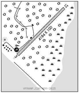
MINCHUMINA (MHM)(PAMH) 0 SE UTC–9(–8DT) N63°53.16′ W152°18.11′
682 B NOTAM FILE MHM

RWY 03–21: 4184X100 (GRVL) MIRL
RWY 03: PAPI(P4L)–GA 3.0° TCH 35′. Trees.
RWY 21: Trees.
SERVICE: LGT ACTVT PAPI Rwy 03; MIRL Rwy 03–21–CTAF.
AIRPORT REMARKS: Unattended. Rwy cond not mnt; rcmd vsb insp prior to lndg. Cold temperature airport. Altitude correction required at or below –36C. Wind indicator: inaccurate; surrounded by trees. Alert: clsd cross rwy with faded markings W of Rwy 03 thr. Snow removal ops–CTAF. BLM fire fighting equip & acft opr durg summer months.
AIRPORT MANAGER: (907) 451-5280
WEATHER DATA SOURCES: AWOS–3P 135.55 (907) 674–3315. (WX CAM)
COMMUNICATIONS: CTAF 122.9
MINCHUMINA RCO 122.2 (FAIRBANKS RADIO)
ANCHORAGE CENTER APP/DEP CON 120.9 319.2
RADIO AIDS TO NAVIGATION: NOTAM FILE MHM.
NDB (HW) 227 MHM N63°53.03′ W152°18.97′ at fld. 713/17E.
NDB unusable:
230°–240°
345°–350° byd 25 NM
COMM/NAV/WEATHER REMARKS: For a toll free call to Fairbanks FSS dial 1–866–248–6516.