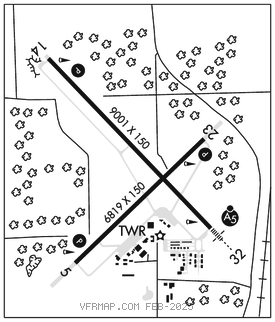
MANSFIELD LAHM RGNL (MFD)(KMFD) P (ANG) 3 N UTC–5(–4DT) N40°49.29′ W82°31.00′
1297 B ARFF Index–See Remarks NOTAM FILE MFD

RWY 14–32: H9001X150 (ASPH–GRVD) S–150, D–185, 2S–175, 2D–300 PCN 62 F/B/W/U HIRL
RWY 14: PAPI(P4L)–GA 3.0° TCH 42′. RVR–R Road. 0.9% up.
RWY 32: MALSR. RVR–T Trees.
RWY 05–23: H6819X150 (ASPH–GRVD) S–90, D–96, 2S–175, 2D–150 PCN 55 F/B/W/U HIRL
RWY 05: REIL. PAPI(P4L)–GA 3.0° TCH 50′.
RWY 23: REIL. PAPI(P4L)–GA 3.0° TCH 45′. Trees.
LAND AND HOLD–SHORT OPERATIONS
LDG RWY HOLD–SHORT POINT AVBL LDG DIST
RWY 05 14–32 4363
RWY 14 05–23 6100
RUNWAY DECLARED DISTANCE INFORMATION
RWY 05: TORA–6819 TODA–6819 ASDA–6819 LDA–6819
RWY 14: TORA–9001 TODA–9001 ASDA–9001 LDA–9001
RWY 23: TORA–6819 TODA–6819 ASDA–6819 LDA–6819
RWY 32: TORA–9001 TODA–9001 ASDA–9001 LDA–9001
SERVICE: S4 FUEL 100LL, JET A LGT When ATCT clsd actvt MALSR Rwy 32; REIL Rwy 05 & 23; PAPI Rwy 14, 05, & 23; HIRL Rwy 05–23 & 14–32–CTAF. FLUID LOX
AIRPORT REMARKS: Attended Mon–Fri 1200–0000Z‡. Sat–Sun 1300–2300Z‡. Deer, birds, & waterfowl on & invof arpt. Class IV, ARFF Index A. Clsd to skedd acr ops gtr than 9 pax seats – call amgr. 11 ft fence, 95 ft fm Twy A cntrln btn AER 05 & Twy F, does not have rqrd clnc fm twy cntrln. Acft on either end of Rwy 05–23 and Rwy 14–32 cannot be seen on the other end due to rwy grade. Acft larger than a "G1" or with a wing span greater than 80′ (tip to tip) are restricted on Twys G/H/J/L/M/N and should use the main ramp area. Acft with wingspan exceeding 132′ are rstd to 15 mph along mil ramp on Twy A. FBO after hrs ctc 419–524–4261 or 419–989–2911. Ldg fees on all coml oprs invoiced on monthly; for otr arngmts ctc amgr.
AIRPORT MANAGER: 419-522-2191
WEATHER DATA SOURCES: ASOS 125.3 (419) 520–4785. LAWRS.
COMMUNICATIONS: CTAF 119.8 ATIS 125.3 UNICOM 122.95
RCO 122.6 (CLEVELAND RADIO)
®CLEVELAND APP/DEP CON 128.35 (1100–0600Z‡)
®CLEVELAND CENTER APP/DEP CON 134.9 (0600–1100Z‡)
TOWER 119.8 (1100–0400Z‡) GND CON 121.8
CLEARANCE DELIVERY PHONE: For CD ctc Cleveland ARTCC at 440-774-0223.
AIRSPACE: CLASS D svc 1100–0400Z‡; other times CLASS E.
RADIO AIDS TO NAVIGATION: NOTAM FILE MFD.
(L) (L) VORTACW 108.8 MFD Chan 25 N40°52.12′ W82°35.46′ 133° 4.4 NM to fld. 1222/3W.
TACAN AZIMUTH unusable:
075°–095°
151°–214° byd 30 NM
VOR unusable:
151°–214° byd 15 NM
DME unusable:
151°–214° byd 30 NM
MANNS NDB (MHW/LOM) 372 MF N40°45.98′ W82°26.71′ 321° 4.6 NM to fld. 1312/6W.
ILS 110.5 I–MFD Rwy 32. Class IA. LOM MANNS NDB. Unmonitored when ATCT clsd. LOC unusable byd 25° left and right of course.