CARBONDALE/MURPHYSBORO
SOUTHERN ILLINOIS (MDH)(KMDH) 3 NW UTC–6(–5DT) N37°46.69′ W89°15.12′ 411 B ARFF Index–See Remarks NOTAM FILE MDH
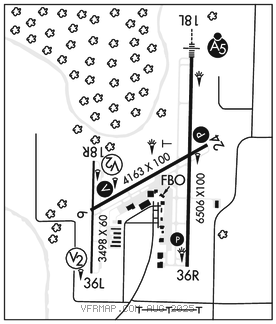
RWY 18L–36R: H6506X100 (ASPH–GRVD) 2S–126 PCR 270 F/D/X/T HIRL
RWY 18L: MALSR.
RWY 36R: REIL. PAPI(P4L)–GA 3.0° TCH 45′.
RWY 06–24: H4163X100 (ASPH–PFC) S–86, D–110, 2D–167 PCR 350 F/D/X/T MIRL
RWY 06: REIL. VASI(V4L)–GA 3.5° TCH 48′.
RWY 24: REIL. PAPI(P4R)–GA 3.5° TCH 25′.
RWY 18R–36L: H3498X60 (ASPH) PCR 40 F/D/X/T MIRL
RWY 18R: PVASI(PSIL)–GA 3.0° TCH 27′.
RWY 36L: PVASI(PSIL)–GA 3.0° TCH 25′.
LAND AND HOLD–SHORT OPERATIONS
LDG RWY HOLD–SHORT POINT AVBL LDG DIST
RWY 06 18L–36R 3100
RWY 24 18R–36L 3800
RWY 36R 06–24 3000
RUNWAY DECLARED DISTANCE INFORMATION
RWY 06: TORA–4163 TODA–4163 ASDA–4163 LDA–4163
RWY 18L:TORA–6506 TODA–6506 ASDA–6506 LDA–6506
RWY 18R:TORA–3498 TODA–3498 ASDA–3498 LDA–3498
RWY 24: TORA–4163 TODA–4163 ASDA–4163 LDA–4163
RWY 36L:TORA–3498 TODA–3498 ASDA–3498 LDA–3498
RWY 36R:TORA–6506 TODA–6506 ASDA–6506 LDA–6506
SERVICE: S4 FUEL 100LL, JET A LGT ACTIVATE MALSR Rwy 18L; VASI Rwy 06; PAPI Rwy 24 and Rwy 36R; MIRL Rwy 06–24; HIRL Rwy 18L–36R–CTAF. When twr clsd HIRL Rwy 18L–36R preset med ints, increase ints–CTAF. When twr clsd Rwy 18R–36L ltg by req only–call 618–534–3662. Rwy 18R PVASI unusable byd 6° right of course, PVASI OTS indef.
AIRPORTREMARKS:Attended continuously. Birds on and invof arpt. High student training activity. Class IV, ARFF Index A. Clsd to sked acr ops gtr than 9 psgr seats. Unsked acr ops gtr than 30 psgr seats rqr 24 hr PPR–Call amgr Mon–Fri. Rwy 06–24 not avbl for unscheduled acr at least 31 psgr seats. Rwy 18R–36L not avbl for unscheduled acr at least 31 psgr seats. Rwy 06–24 restricted to acft 12,500 pounds or less; unless PPR with twr. Rwy 06 and Rwy 18R–36L intersect. Verify correct compass heading for Rwy 06 deps.
AIRPORT MANAGER: 618-529-1721
WEATHER DATA SOURCES: ASOS (618) 529–1821 LAWRS.
COMMUNICATIONS: CTAF 125.35 ATIS 119.725 UNICOM 122.95
KANSAS CITY CENTER APP/DEP CON 127.475
TOWER 125.35 (1300–0300Z‡) GND CON 121.8
AIRSPACE: CLASS D svc 1300–0300Z‡; other times CLASS G.
RADIO AIDS TO NAVIGATION: NOTAM FILE MDH.
CABBI NDB (LOMW) 388 MD N37°52.21′ W89°14.73′ 184° 5.5 NM to fld. 409/1W. NDB unmonitored when ATCT clsd.
ILS 110.9 I–MDH Rwy 18L. Class IE. LOM CABBI NDB. Unmonitored when ATCT clsd.