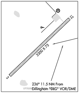
MANOKOTAK (MBA)(PAMB) 6 ESE UTC–9(–8DT) N58°55.92′ W158°54.11′
107 B NOTAM FILE MBA

RWY 03–21: 3300X75 (GRVL) MIRL
RWY 03: Tree.
RWY 21: Tree.
SERVICE: LGT ACTIVATE MIRL Rwy 03–21, rotating bcn and windsock lgt–CTAF.
AIRPORTREMARKS: Unattended. Recommend visual inspection prior to use. Increased wildlife activity on or around arpt. Rwy 03–21 edge lights white full length of rwy. Rwy 03–21 safety are dimensions 3900′ by 150′.
AIRPORT MANAGER: 907-842-5511
WEATHER DATA SOURCES: AWOS–3P 120.625 (907) 289–2018. (WX CAM)
COMMUNICATIONS: CTAF 122.9
RADIO AIDS TO NAVIGATION: NOTAM FILE DLG.
DILLINGHAM (H)(H)VORW/DME 116.4 DLG Chan 111 N58°59.65′ W158°33.13′ 236° 11.5 NM to fld. 81/15E.
COMM/NAV/WEATHER REMARKS: For a toll free call to Kenai FSS dial 1–866–864–1737.