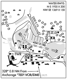
LAKE HOOD (LHD)(PALH) P (ANG) 3 SW UTC–9(–8DT) N61°11.20′ W149°57.92′
79 TPA–See Remarks NOTAM FILE LHD

RWY 14–32: 2200X75 (GRVL–DIRT) MIRL
RWY 14: Tree.
RWY 32: Tree. Rgt tfc.
SERVICE: S4 FUEL 100, 100LL, JET A LGT SS–SR.
NOISE: Noise sensitive area in effect–Amgr for info.
AIRPORT REMARKS: Special Air Traffic Rules–Part 93, see Regulatory Notices. Attended continuously. 100LL lctd Rwy 14–32 tsnt prkg & FBO. Waterfowl, nesting and lrg flocks of birds spring/fall invof arpt. TPA–673(600). Non–rdo ops PPR–907–271–5936; Req tsfr to ATCT; Rmn wi 15 min of ETA. Ngt non–rdo ops NA. CAUTION: PAEW; Twy/Road around Lake Hood multi use; Rcmd lndg lgt durg tax. Rwy 14–32 tfc pat overlaps seadrome pat. Rwy 14–32 ltd to 9000 lb or less. Public ramps on N and W shore of Lake Hood. Area NW and SW of Lake Spenard from canal eastward 1500 ft not vsbl from ATCT. Twy V PCL security gate east of Twy E, key 121.75 3 times. Twy H–2/Lakeshore twy gates PCL; Key 121.75 3 times. Arr/Dep routes; See Area Notices. See Notice in Section C for arpt layout graphic.
AIRPORT MANAGER: 907-266-2741
WEATHER DATA SOURCES: ASOS 125.6 (907) 245–5432. (WX CAM)
COMMUNICATIONS: CTAF 126.8 ATIS 125.6 (907–245–5432)
®ANCHORAGE APP/DEP CON 119.1 363.2
TOWER 126.8 (907–245–5432)
CLNC DEL 119.4
AIRSPACE: CLASS D.
RADIO AIDS TO NAVIGATION: NOTAM FILE ANC.
ANCHORAGE (H) (H)VORW/DME 113.15 TED Chan 78(Y) N61°10.07′ W149°57.61′ 334° 1.1 NM to fld. 92/18E.
VOR unusable:
041°–091° byd 25 NM blo 15,000′
091°–096° byd 20 NM blo 15,000′
096°–121° byd 25 NM blo 12,500′
121°–146° byd 25 NM blo 9,000′
DME unusable:
041°–091° byd 25 NM blo 15,000′
091°–096° byd 20 NM blo 15,000′
096°–121° byd 25 NM blo 12,500′
121°–146° byd 25 NM blo 9,000′
196°–206° byd 25 NM blo 3,500′
206°–211° byd 25 NM blo 4,000′
211°–221° byd 25 NM blo 3,500′
COMM/NAV/WEATHER REMARKS: For a toll free call to Kenai FSS dial 1–866–864–1737. • • • • • • • • • • • • • • • • • •
WATERWAY E–W: 4541X188 (WATER)
WATERWAY N–S: 1930X200 (WATER)
WATERWAY SE–NW: 1369X150 (WATER)
SEAPLANE REMARKS: Waterlanes to Lake Hood Seaplane Base elev 76′. N pothole dsgnd no wake area. Lake clsd to acft over 12,500 lbs freezeup–Dec 31, overflows into ice may ocr durg winter. For prior winter ski ops avblty–lcl NOTAMS and twr. Floating debris on lake.