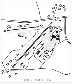
LEXINGTON
BLUE GRASS (LEX)(KLEX) 4 W UTC–5(–4DT) N38°02.20′ W84°36.52′ 980 B ARFF Index–See Remarks NOTAM FILE LEX MON Airport

RWY 04–22: H7004X150 (ASPH–GRVD) S–140, D–169, 2S–175, 2D–275 PCR 563 R/A/W/T HIRL CL 0.5% up NE
RWY 04: MALSR. TDZL. PAPI(P4L)–GA 3.0° TCH 60′. RVR–T Tree.
RWY 22: REIL. PAPI(P4L)–GA 3.0° TCH 60′. Tree.
RWY 09–27: H4000X75 (CONC) S–30 PCR 262 R/B/W/T MIRL 0.6% up E
RWY 09: REIL. PAPI(P4L)–GA 3.0° TCH 43′.
RWY 27: REIL. PAPI(P4L)–GA 3.0° TCH 43′.
RUNWAY DECLARED DISTANCE INFORMATION
RWY 04: TORA–7004 TODA–7004 ASDA–7004 LDA–6604
RWY 09: TORA–4000 TODA–4000 ASDA–4000 LDA–4000
RWY 22: TORA–7004 TODA–7004 ASDA–7004 LDA–6604
RWY 27: TORA–4000 TODA–4000 ASDA–4000 LDA–4000
ARRESTING GEAR/SYSTEM
RWY 04: EMAS
RWY 22: EMAS
SERVICE: S4 FUEL 100LL, JET A OX 1, 2, 3
AIRPORT REMARKS: Attended continuously. Engineered material arresting system (EMAS) 316′ in length by 170′ in width starting 186′ DER 04. Engineered material arresting system (EMAS) 316′ in length by 170′ in width starting 307′ DER 22. Class I, ARFF Index C. Twy B and Twy F west of Twy F3; not avbl for sked acr ops more than 9 pax seats or unsked acr at least 31 pax seats; clsd to acft with wingspan greater than 78 ft. Rwy 09–27 not avbl for sked acr ops more than 9 pax seats or unsked acr at least 31 pax seats. ICS/Index D ARFF cpblitys upon req. Durg L pat, do not mistake Rwy 27 for Rwy 22. Wall mural bfr Rwy 22 thr gives illusion of a bridge. Flight Notification Service (ADCUS) avbl. User fee arpt.
AIRPORT MANAGER: 859-425-3100
WEATHER DATA SOURCES: ASOS (859) 281–5700 LLWAS.
COMMUNICATIONS: ATIS 126.3 UNICOM 122.95
LEXINGTON RCO 122.1R 112.6T (LOUISVILLE RADIO)
LEXINGTON RCO 122.6 (LOUISVILLE RADIO)
®APP/DEP CON 120.15 (040°–220°) 120.75 (221°–039°)
TOWER 119.1 GND CON 121.9 CLNC DEL 132.35
AIRSPACE: CLASS C svc ctc APP CON.
RADIO AIDS TO NAVIGATION: NOTAM FILE LEX.
LEXINGTON (VL) (L) VOR/DME 112.6 HYK Chan 73 N37°57.98′ W84°28.35′ 303° 7.7 NM to fld. 1035/0E.
ILS 110.1 I–LEX Rwy 04. Class IA. Glideslope unusable 0.3 NM to thld.
ILS 111.75 I–GNJ Rwy 22. Class IA. LOC unusable byd 20° left and 20° right of course.