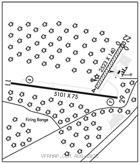
POTTSVILLE
SCHUYLKILL CO/JOE ZERBEY (ZER)(KZER) 8 W UTC–5(–4DT) N40°42.41′ W76°22.43′ 1730 B NOTAM FILE IPT

RWY 11–29: H5101X75 (ASPH) S–21 MIRL 0.5% up W
RWY 11: REIL. PAPI(P2L)–GA 3.0° TCH 40′. Trees.
RWY 29: REIL. PAPI(P2L)–GA 3.0° TCH 45′. Trees.
RWY 04–22: 2523X140 (TURF) 0.4% up NE
RWY 22: Thld dsplcd 200′. Trees.
SERVICE: S2 FUEL 100LL, JET A LGT ACTIVATE REIL Rwy 11 and 29; MIRL Rwy 11–29–CTAF. PAPI Rwy 11 and 29 on continuously.
AIRPORTREMARKS: Attended Mon–Fri 1230–2200Z‡, Sat–Sun on call. For svc after hrs 570–617–6002. AVGAS self serve with credit card. JET A self serve with credit card. GPU avbl for AC/DC power. Deer on and invof arpt. Rwy 04–22 not maintained winter months. Rwy 04–22 edge and dsplcd thld marked with orange cones.
AIRPORT MANAGER: (570) 617-6002
WEATHER DATA SOURCES: AWOS–3 127.575 (570) 544–2778.
COMMUNICATIONS: CTAF/UNICOM 123.075
®HARRISBURG APP/DEP CON 118.25
CLEARANCEDELIVERY PHONE:For CD ctc Harrisburg Apch at 800-932-0712.
RADIO AIDS TO NAVIGATION: NOTAM FILE IPT.
RAVINE (L) (L) VORTACW 114.6 RAV Chan 93 N40°33.20′ W76°35.96′ 059° 13.8 NM to fld. 175011W.