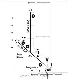
ULYSSES (ULS)(KULS) 1 N UTC–6(–5DT) N37°36.24′ W101°22.41′
3071 B NOTAM FILE ICT

RWY 17–35: H6000X100 (CONC) S–45, D–60 PCN 19 R/C/X/U MIRL
RWY 17: REIL. PAPI(P4L)–GA 3.0° TCH 43′. P–line.
RWY 35: REIL. PAPI(P4L)–GA 3.0° TCH 42′.
RWY 12–30: H4600X60 (CONC) S–12.5 PCN 7 R/C/X/U MIRL
RWY 12: PAPI(P2L)–GA 3.0° TCH 38′. Road.
RWY 30: PAPI(P2L)–GA 3.0° TCH 39′. Antenna.
SERVICE: S4 FUEL 100LL, JET A LGT ACTVT REIL Rwy 17 & 35; PAPI Rwy 12, 17, 30 and 35; MIRL Rwys 12–30 and 17–35–CTAF.
AIRPORTREMARKS: Attended Mon–Sat 1400–0000Z‡. Glider and ultralight activity on and invof arpt.
AIRPORT MANAGER: 620-952-0954
WEATHER DATA SOURCES: AWOS–3PT 118.95 (620) 424–3747.
COMMUNICATIONS: CTAF/UNICOM 122.8
RCO 122.3 (WICHITA RADIO)
®KANSAS CITY CENTER APP/DEP CON 125.2
CLEARANCE DELIVERY PHONE: For CD if una to ctc on FSS freq, ctc Kansas City ARTCC at 913-254-8508.
RADIO AIDS TO NAVIGATION: NOTAM FILE GCK.
GARDEN CITY (VH) (H) VORTACW 113.3 GCK Chan 80 N37°55.14′ W100°43.50′ 228° 36.2 NM to fld. 2878/11E.
TACAN AZIMUTH unusable:
280°–010° blo 4,000′
280°–010° byd 11 NM