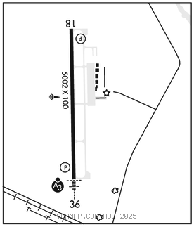
VICKSBURG TALLULAH RGNL (TVR)(KTVR) 9 E UTC–6(–5DT) N32°21.10′ W91°01.66′
86 B TPA–1086(1000) NOTAM FILE TVR

RWY 18–36: H5002X100 (ASPH) S–60, D–75 MIRL
RWY 18: REIL. PAPI(P4L)–GA 3.0° TCH 50′. Trees.
RWY 36: SSALR. PAPI(P4L)–GA 3.0° TCH 50′. Trees.
RUNWAY DECLARED DISTANCE INFORMATION
RWY 18: TORA–5002 TODA–5002 ASDA–5002 LDA–5002
RWY 36: TORA–5002 TODA–5002 ASDA–5002 LDA–5002
SERVICE: S4 FUEL 100LL, JET A LGT MIRL Rwy 18–36, REIL Rwy 18, SSALR Rwy 36 preset low ints dusk–dawn, to increase ints ACTVT–CTAF.
AIRPORTREMARKS:Attended 1300–2330Z‡. Holidays 1600–2200Z‡. For arpt mgr aft hrs call 318–366–1615. PAEW on arpt. Migratory birds invof arpt. Crop dusting activity 2 NM radius of arpt. Pilots in tfc pattern are requested to avoid over flight of Mound, LA 1/2 mile south and east of Rwy 36.
AIRPORT MANAGER: 318-574-5841
WEATHER DATA SOURCES: ASOS 118.525 (318) 574–4866.
COMMUNICATIONS: CTAF/UNICOM 123.0
MEMPHIS CENTER APP/DEP CON 132.5
CLEARANCE DELIVERY PHONE: For CD ctc Memphis ARTCC at 901-368-8453/8449.
RADIO AIDS TO NAVIGATION: NOTAM FILE GWO.
MAGNOLIA (VH) (H) VORTACW 113.2 MHZ Chan 79 N32°26.04′ W90°05.99′ 265° 47.4 NM to fld. 407/1W.
TACAN AZIMUTH unusable:
240°–275° byd 30 NM blo 2,000′
DME unsbl 240–275 byd 30 NM blo 2000
TALLULAH NDB (MHW/LOM) 344 TKH N32°14.72′ W91°01.55′ 357° 6.4 NM to fld. 79/2E. NOTAM FILE DRI.
ILS 109.7 I–TVR Rwy 36. Class ID.