TEMPLE
DRAUGHON–MILLER CENTRAL TEXAS RGNL (TPL)(KTPL) 5 NW UTC–6(–5DT) N31°09.11′ W97°24.46′ 682 B NOTAM FILE TPL

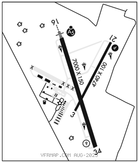
RWY 16–34: H7000X150 (ASPH–GRVD) S–55, D–70, 2D–110 MIRL
RWY 16: MALSR.
RWY 34: PAPI(P4L)–GA 3.0° TCH 34′.
RWY 03–21: H4740X100 (ASPH) S–31, D–37 MIRL
RWY 21: PAPI(P4L)–GA 3.0° TCH 47′.
RUNWAY DECLARED DISTANCE INFORMATION
RWY 03: TORA–4740 TODA–4740 ASDA–4740 LDA–4740
RWY 16: TORA–7000 TODA–7000 ASDA–7000 LDA–7000
RWY 21: TORA–4740 TODA–4740 ASDA–4740 LDA–4740
RWY 34: TORA–7000 TODA–7000 ASDA–7000 LDA–7000
SERVICE: S4 FUEL 100LL, JET A, A1+ LGT Dusk–0400Z‡. ACTVT PAPI Rwy 21–CTAF. Aft 0400Z‡ MIRL Rwy 16–34 preset low intst; to incr intst and ACTVT MALSR Rwy 16–CTAF. MIRL Rwy 03–21 not avbl aft 0400Z‡.
AIRPORT REMARKS: Attended 1300–0200Z For aft hrs atndt 254–493–8530. Gldr opn 1.5 miles north of Rwy 16 thr. ARFF not avbl 0200–1300Z‡. ARFF protection meets Index B. 100LL and all fuels full and self svc. Military contract fuel avbl.
AIRPORT MANAGER: 254-298-5770
WEATHER DATA SOURCES: AWOS–3PT 134.975 (254) 774–8337.
COMMUNICATIONS: CTAF/UNICOM 123.0
RCO 122.6 (SAN ANGELO RADIO)
®GRAY APP/DEP CON 120.075 CLNC DEL 125.9
AIRSPACE: CLASS E svc 1200–0500Z‡; other times CLASS G.
RADIO AIDS TO NAVIGATION: NOTAM FILE TPL.
TEMPLE (L) DME 116.35 TPL Chan 110(Y) N31°12.56′ W97°25.50′ 165° 3.6 NM to fld. 710.
ILS/DME 111.5 I–TPL Chan 52 Rwy 16. Class IE. LOC unusable byd 20° right of course, Fort Hood MOA. Unmonitored.