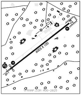
ROXBORO
RALEIGH RGNL AT PERSON CO (TDF)(KTDF) 6 S UTC–5(–4DT) N36°17.08′ W78°59.08′ 609 B NOTAM FILE TDF

RWY 06–24: H6005X100 (ASPH) S–45, D–68 MIRL
RWY 06: MALSR. PAPI(P4L)–GA 3.0° TCH 41′. Thld dsplcd 303′.
RWY 24: REIL. PAPI(P2L)–GA 3.0° TCH 44′. Trees.
SERVICE: FUEL 100LL, JET A1+ LGT REIL Rwy 24; MIRL Rwy 06–24 opr SS–SR; to actvt otr times and actvt MALSR Rwy 06; PAPI Rwy 06 & 24–CTAF.
AIRPORT REMARKS: Attended 1400–2200Z‡. Arpt unatndd Thanksgiving and Christmas. For svc aft hrs call 615–351–9845. Deer and birds on and invof arpt. No line of sight btn rwy ends. Conc helipad, adj and NE of main apron, unlgtd, VFR only.
AIRPORT MANAGER: 336-364-1111
WEATHER DATA SOURCES: AWOS–3 126.725 (336) 364–1651.
COMMUNICATIONS: CTAF/UNICOM 122.7
®RALEIGH APP/DEP CON 132.35
GCO 119.7 (RALEIGH APCH)
CLEARANCE DELIVERY PHONE: For CD if una via GCO ctc Raleigh Apch at 919-380-3144.
RADIO AIDS TO NAVIGATION: NOTAM FILE DCA.
SOUTH BOSTON (L) (L) VORTAC 110.4 SBV Chan 41 N36°40.50′ W79°00.87′ 181° 23.4 NM to fld. 5205W.
ILS/DME 108.7 I–TDF Chan 24 Rwy 06. Class IB. ILS/DME unmonitored.