TUSCALOOSA NTL (TCL)(KTCL) 3 NW UTC–6(–5DT) N33°13.24′ W87°36.68′
170 B ARFF Index–See Remarks NOTAM FILE TCL
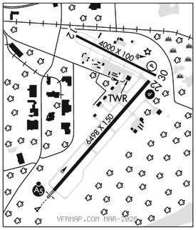
RWY 04–22: H6498X150 (ASPH–GRVD) S–120, D–250, 2D–450, 2D/2D2–972 PCR 1059 F/D/X/T HIRL
RWY 04: MALSR.
RWY 22: PAPI(P4L)–GA 3.0° TCH 50′. Tree.
RWY 12–30: H4000X100 (ASPH) S–15 PCR 50 F/C/X/T MIRL No Part 121/Part 380 Ops
RWY 12: Tree.
RWY 30: PAPI(P4R)–GA 3.5° TCH 73′. Trees.
SERVICE: S4 FUEL 100LL, JET A OX 2 LGT When ATCT clsd ACTVT HIRL Rwy 04–22, MALSR Rwy 04, PAPI Rwy 22, MIRL Rwy 12–30 and twy lgts–CTAF.
AIRPORT REMARKS: Attended 1100–0400Z‡. Birds and deer on and invof arpt. Rwy 12–30 lgtd as a visual rwy. Class IV, ARFF Index A. 24 hr PPR rqr for unsked ACR opns gtr than 30 pax seats 0330–1100Z‡–ctc amgr. Index B ARFF capability avbl H24. Lndg fee.
AIRPORT MANAGER: 205-248-5300
WEATHER DATA SOURCES: ASOS 132.825 (205) 750–8940.
COMMUNICATIONS: CTAF 126.3 UNICOM 122.95
TUSCALOOSA RCO 122.2 (ANNISTON RADIO)
®BIRMINGHAM APP/DEP CON 120.15
TOWER 126.3 (1300–0200Z‡) GND CON 121.8 CLNC DEL 120.775
CLEARANCE DELIVERY PHONE: For CD when twr clsd, ctc Birmingham Apch at 205-769-3890.
AIRSPACE: CLASS D svc 1300–0200Z‡; other times CLASS G.
RADIO AIDS TO NAVIGATION: NOTAM FILE ANB.
CRIMSON (H) TACAN Chan 125 LDK (117.8) N33°15.53′ W87°32.21′ 242° 4.4 NM to fld. 365/3W.
TACAN AZIMUTH unusable:
100°–170°
ILS/DME 109.1 I–TCL Chan 28 Rwy 04. Class IB. Unmonitored when ATCT clsd.