ST LOUIS LAMBERT INTL (STL)(KSTL) 10 NW UTC–6(–5DT) N38°44.92′ W90°22.20′
617 B LRA Class I, ARFF Index D NOTAM FILE STL
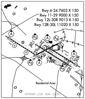
RWY 12R–30L: H11020X150 (CONC–GRVD) S–75, D–200, 2S–175, 2D–350, 2D/2D2–760 PCR 905 R/D/W/T HIRL CL
RWY 12R: MALSR. TDZL. PAPI(P4L)–GA 3.0° TCH 71′. RVR–TR Thld dsplcd 468′. Tree. Rgt tfc.
RWY 30L: MALSR. PAPI(P4R)–GA 3.0° TCH 58′. RVR–TR Thld dsplcd 201′. Tree. 0.7% down.
RWY 12L–30R: H9013X150 (CONC–GRVD) S–75, D–200, 2S–175, 2D–350, 2D/2D2–760 PCR 1410 R/D/W/T HIRL CL
RWY 12L: ALSF2. TDZL. PAPI(P4R)–GA 3.0° TCH 60′. RVR–TMR Tree. 0.7% up.
RWY 30R: ALSF2. TDZL. PAPI(P4R)–GA 3.0° TCH 55′. RVR–TMR Tree. Rgt tfc. 1.0% down.
RWY 11–29: H9000X150 (CONC–GRVD) S–75, D–200, 2D–325, 2D/2D2–700 PCR 1100 R/D/W/T HIRL CL
RWY 11: ALSF2. TDZL. PAPI(P4R)–GA 3.0° TCH 67′. RVR–TMR Rgt tfc. 0.6% down.
RWY29:ALSF2. TDZL. PAPI(P4L)–GA 3.0° TCH 73′. RVR–TMR Tree. 0.7% up.
RWY 06–24: H7603X150 (CONC–GRVD) S–75, D–176, 2S–175, 2D–280, 2D/2D2–660 PCR 600 R/D/W/T HIRL
RWY 06: MALSR. PAPI(P4R)–GA 3.0° TCH 51′. RVR–TR Tree.
RWY 24: MALS. PAPI(P4L)–GA 3.0° TCH 53′. RVR–TR Sign.
RUNWAY DECLARED DISTANCE INFORMATION
RWY 06: TORA–7603 TODA–7603 ASDA–7323 LDA–7323
RWY 11: TORA–9000 TODA–9000 ASDA–9000 LDA–9000
RWY 12L:TORA–9013 TODA–9013 ASDA–8956 LDA–8956
RWY 12R:TORA–11020TODA–11020 ASDA–11020 LDA–10553
RWY 24: TORA–7603 TODA–7603 ASDA–7603 LDA–7603
RWY 29: TORA–9000 TODA–9000 ASDA–9000 LDA–9000
RWY 30L:TORA–11020 TODA–11020 ASDA–10880 LDA–10679
RWY 30R:TORA–9013 TODA–9013 ASDA–9013 LDA–9013
ARRESTING GEAR/SYSTEM
RWY 12R BAK–14 BAK –12B(B) (1090') BAK–14 BAK –12B(B) (1300') RWY 30L
RWY 06 BAK–14 BAK –12B(B) (1450')
SERVICE: S4 FUEL 100LL, JET A OX 1, 2, 3, 4 MILITARY–A–GEAR Retractable BAK–12B(B) avbl Rwy 06, 12R, and 30L. A–G are kept in recessed posn til req for use. Twr must be notified at least 5 sec prior to engagement so that cable may be raised. JASU 1(AM32A–60A) 5(MA–1A) FUEL 100LL A FLUID SP LHOX OIL O–128–133–(148 Mil) SOAP
AIRPORT REMARKS: Attended continuously. Fuel: A: Jet–A. Twy D or Taxilane C from Twy S to Twy G, B–747 or larger acft are not authorized to pass or be passed by B–767 or larger acft operating on the parallel Twy/Taxilane. Twy November btn Rwy 24 and Foxtrot, rstrd to acft with a wingspan of less than 79 ft (CRJ–900 or smlr) when acft are parked on the November Pad. This area is rstrd to all opns when acft are performing end run–ups in the November Pad. Taxiway Victor, underlying the Runway 12L final approach course is restricted to aircraft with a tail height of 25′ or less (CRJ–700 or smaller), when aircraft are landing on Runway 12L. Txl Charlie, east of Twy Charlie 2 to Twy G, rstrd to B737 or smlr acft (wingspan less than 118′) when acft are parked on the Hotel pad. Txl Charlie from Twy Charlie Six to Twy Charlie four, rstrd to B757–300 series or smlr when passing bhnd acft that have made the initial 10 ft pushback. Twy A east of Twy T, Twy S and Rwy 06–24 south of Twy B, no acft or vehicle ops when arriving or departing Rwy 11 or arriving Rwy 29. Taxiway Lima, north of Runway 12L–30R, aircraft larger than a Gulfstream VI taxiing northbound are prohibited from making a right turn eastbound on Taxiway Foxtrot. Twy V2 is unavbl to B–767 or larger acft (wingspan 118′ or greater). Twy V2, B–737 (wingspan greater than 79′ but less than 118′) must perform judgmental oversteering instead of cockpit over cntrln steering when tax. Twy K1 is unavbl to B–767 or larger acft (wingspan 118′ or greater). Twy Echo, btn Twy November and Twy Lima rstrd to B–767 or smlr acft (wingspand less than 171 ft) when acft are parked on the Echo Pad. Twy Charlie, fm Twy Sierra to Twy Charlie Seven, rstrd to B–767 or smlr acft (156 ft avbl) when acft are parked in the Charlies Pad. Rstrn is for tax acft, lrgr acft may be towed thru area. Twy Charlie, from Twy Charlie Seven to Twy Charlie Six, rstrd to a B757–300 series or smlr. Wg tip clnc with gnd veh not adqt alg N side of main trml apn. ASDE–X in use. Operate transponders with altitude reporting mode and ADS–B (if equipped) enabled on all airport surfaces. Waiver to conduct simul apchs to parl rys separated by 1,300 ft in efct. Ldg fee: Ldg fee based on acft weight collected by FBO. Flight Notification Service (ADCUS) avbl.
AIRPORT MANAGER: 314-426-8000
WEATHER DATA SOURCES: ASOS (314) 238–8419 LAWRS. LLWAS. TDWR.
COMMUNICATIONS: D–ATIS 125.025 379.925 (314)890–4777 UNICOM 122.95
ST LOUIS RCO 122.6 (ST LOUIS RADIO)
®ST LOUIS APP CON 132.125 360.6
ST LOUIS TOWER 118.5 257.7(Rwy 12R–30L) 120.05 284.6(Rwy 12L–30R, 24) 132.475 239.275(Rwy 06, 11–29)
ST LOUIS GND CON 121.9 348.6(Inbound) 121.65 377.175(Outbound) 118.925 227.125(Rwy 11–29)
GND METERING 127.55 360.2(East) 121.075 346.35(West)
CLNC DEL 119.5 363.1
®ST LOUIS DEP CON 128.1 307.05(S/W) 119.15 335.5(N/E)
CPDLC (LOGON KUSA)
PDC
AIRSPACE: CLASS B See VFR Terminal Area Chart.
VOR TEST FACILITY (VOT) 111.0
RADIO AIDS TO NAVIGATION: NOTAM FILE STL.
CARDINAL (DL) DME 116.45 CSX Chan 111(Y) N38°45.16′ W90°21.66′ at fld. 556.
DME unusable:
027°–033° byd 30 NM blo 4,500′
041°–138° byd 25 NM blo 4,500′
164°–234° byd 15 NM blo 3,000′
164°–234° byd 24 NM blo 4,500′
300°–016° byd 33 NM blo 4,500′
(VH) (H) VORTACW 117.4 STL Chan 121 N38°51.64′ W90°28.94′ 141° 8.5 NM to fld. 446/1E.
VOR unusable:
006°–016° byd 40 NM blo 7,000′
006°–016° byd 62 NM
017°–038° byd 40 NM
039°–049° byd 40 NM blo 18,000′
050°–076° byd 40 NM blo 5,000′
050°–076° byd 50 NM blo 10,000′
050°–076° byd 94 NM blo 18,000′
077°–084° byd 40 NM
085°–099° byd 40 NM blo 2,300′
085°–099° byd 69 NM blo 18,000′
100°–124° byd 40 NM
125°–135° byd 40 NM blo 18,000′
136°–147° byd 40 NM blo 6,000′
136°–147° byd 59 NM
148°–164° byd 40 NM
165°–175° byd 40 NM blo 6,500′
165°–175° byd 77 NM
176°–189° byd 105 NM
176°–189° byd 40 NM blo 14,000′
190°–207° byd 40 NM blo 8,000′
190°–207° byd 70 NM blo 11,000′
190°–207° byd 85 NM blo 18,000′
208°–218° byd 40 NM
219°–229° byd 40 NM blo 2,400′
219°–229° byd 49 NM
230°–241° byd 40 NM blo 18,000′
242°–254° byd 40 NM
255°–265° byd 40 NM blo 18,000′
266°–272° byd 40 NM
273°–286° byd 40 NM blo 7,500′
273°–286° byd 83 NM blo 18,000′
287°–291° byd 40 NM
292°–302° byd 40 NM blo 8,000′
292°–302° byd 70 NM
303°–313° byd 40 NM blo 18,000′
314°–346° byd 40 NM
347°–357° byd 40 NM blo 4,500′
347°–357° byd 65 NM blo 8,000′
347°–357° byd 79 NM
358°–005° byd 40 NM