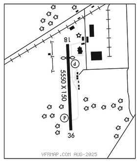
STARKVILLE
GEORGE M BRYAN (STF)(KSTF) 3 SW UTC–6(–5DT) N33°25.99′ W88°50.92′ 333 B NOTAM FILE GWO

RWY 18–36: H5550X150 (ASPH–CONC) S–25, D–30 HIRL
RWY 18: PAPI(P2L)–GA 3.0° TCH 36′. Thld dsplcd 1379′. Sign.
RWY 36: REIL. PAPI(P2L)–GA 3.0° TCH 40′.
SERVICE: S4 FUEL 100LL, JET A LGT 1400–2230Z‡; aft hr ACTVT REIL Rwy 36; HIRL Rwy 18–36–CTAF. PAPI Rwy 18 and 36 opr consly.
AIRPORT REMARKS: Attended Mon–Sat 1400–2300Z‡, Sun 1900–2300Z‡. Jet A full svc aft hrs–ctc AMGR. Fuel avbl 24 hrs with credit card. Experimental acft on and invof of arpt. Pilots must provide their own tiedown ropes.
AIRPORT MANAGER: 662-418-5900
WEATHER DATA SOURCES: AWOS–3PT 118.975 (662) 323–4966.
COMMUNICATIONS: CTAF/UNICOM 122.7
®COLUMBUS APP/DEP CON 135.6 (1300–0100Z‡ Mon–Fri, 1800–2300Z‡ Sun, clsd Sat and hols.)
®MEMPHIS CENTER APP/DEP CON 127.1 (0100–1300Z‡ Mon–Fri, 2300Z–1800Z‡ Sun, Sat and hols.)
COLUMBUS CLNC DEL 126.25
CLEARANCE DELIVERY PHONE: For CD ctc Columbus Apch at 662-434-3044.
RADIO AIDS TO NAVIGATION: NOTAM FILE GWO.
BIGBEE (L) (L) VORTACW 116.2 IGB Chan 109 N33°29.13′ W88°30.82′ 256° 17.1 NM to fld. 245/4E.
VOR unusable:
010°–020°
015°–045° byd 40 NM
070°–100° byd 40 NM
101°–118° byd 56 NM
119°–130° byd 40 NM
157°–206° byd 40 NM
200°–260° blo 5,000′
230°–270° byd 40 NM
280°–295° byd 40 NM
310°–325° byd 40 NM
LOC/DME 109.9 I–STF Chan 36 Rwy 36.