SULPHUR SPRINGS MUNI (SLR)(KSLR) 2 NW UTC–6(–5DT) N33°09.59′ W95°37.27′
489 B NOTAM FILE SLR
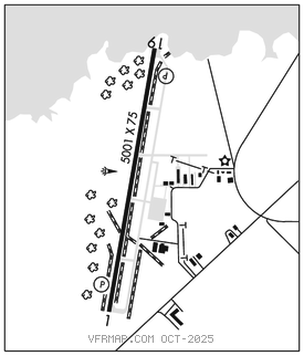
RWY 01–19: H5001X75 (CONC) S–30, D–50 MIRL 0.4% up S
RWY 01: REIL. PAPI(P4L)–GA 3.0° TCH 56′. Fence.
RWY 19: REIL. PAPI(P4L)–GA 3.0° TCH 40′.
SERVICE: S4 FUEL 100LL, JET A LGT MIRL Rwy 01–19 preset low dusk–dawn. To incr intst and ACTVT REIL Rwys 01 and 19–CTAF. PAPI Rwys 01 and 19 opr consly. Rwy 19 PAPI unusbl byd 8 degs right of RCL.
AIRPORT REMARKS: Attended Mon–Sat 1400–0000Z‡. For attendant on Sun call 903–885–49111 durg attended hrs. For attendant after hrs call police dispatch 903–885–7602. 100LL avbl 24 hrs self–serve. Birds on and invof arpt. Lgt sport acft oprg on west side of rwy. Rwy 01 45 ft bldg 1,820 dstc. Rwy 01, 44 ft unmkd p–line, 1530 ft dstc, 30:1; 58 ft tank, 1820 ft dstc, 30 ft L, 27:1; 125 ft antenna, 1515 ft east of Rwy 01 end.
AIRPORT MANAGER: 903-885-4911
WEATHER DATA SOURCES: AWOS–3 118.35 (903) 885–9605.
COMMUNICATIONS: CTAF/UNICOM 123.075
®FORT WORTH CENTER APP/DEP CON 132.025
CLEARANCE DELIVERY PHONE: For CD ctc Fort Worth ARTCC at 817-858-7584.
RADIO AIDS TO NAVIGATION: NOTAM FILE SLR.
(L) DME 109.0 SLR Chan 27 N33°11.92′ W95°32.57′ 240° 4.6 NM to fld. 476.