CHEBOYGAN
CHEBOYGAN CO (SLH)(KSLH) 2 W UTC–5(–4DT) N45°39.22′ W84°31.16′ 640 B NOTAM FILE SLH
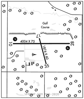
RWY 10–28: H4004X75 (ASPH) S–23, D–34, 2D–60 MIRL 0.3% up W
RWY 10: REIL. PAPI(P2L)–GA 4.0° TCH 40′. Road.
RWY 28: REIL. PAPI(P2L)–GA 4.0° TCH 25′. Trees.
RWY 17–35: H1874X60 (ASPH) MIRL
RWY 35: Trees.
SERVICE: S4 FUEL 100LL, JET A+ LGT ACTVT REIL Rwy 10 and Rwy 28; PAPI Rwy 10 and Rwy 28; MIRL Rwy 10–28 and Rwy 17–35 – CTAF.
AIRPORT REMARKS: Attended Mon–Fri 1300–2100Z‡, Sat–Sun on call. Unatndd Christmas, Easter and Thanksgiving or by arngmt. Deer and birds on and invof arpt. Svcs prvdd wkends by prior arngmt. After hrs trml bldg access: press 5, then 3 & 2 simul, then 1. 100LL avbl H24 self svc; for Jet A after hrs call 989–464–6887 subj call in fee.
AIRPORT MANAGER: 231-627-5571
WEATHER DATA SOURCES: AWOS–3P 118.175 (231) 627–4671.
COMMUNICATIONS: CTAF/UNICOM 122.8
®MINNEAPOLIS CENTER APP/DEP CON 134.6
CLEARANCE DELIVERY PHONE: For CD ctc Minneapolis ARTCC at 651-463-5588.
RADIO AIDS TO NAVIGATION: NOTAM FILE PLN.
PELLSTON (L) (L) VORTACW 111.8 PLN Chan 55 N45°37.84′ W84°39.85′ 083° 6.3 NM to fld. 836/6W.
VOR unusable:
301°–339°
GCP has azm only, no DME at GCP