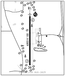
HATTIESBURG–LAUREL
HATTIESBURG/LAUREL RGNL (PIB)(KPIB) 9 N UTC–6(–5DT) N31°28.03′ W89°20.22′ 298 B ARFF Index–See Remarks NOTAM FILE PIB

RWY 18–36: H6503X150 (ASPH–GRVD) S–125, D–225, 2S–175, 2D–275 PCR 860 F/C/X/T HIRL
RWY 18: MALSR. REIL. PAPI(P4L)–GA 3.0° TCH 58′.
RWY 36: REIL. PAPI(P4L)–GA 3.0° TCH 44′.
RUNWAY DECLARED DISTANCE INFORMATION
RWY 18: TORA–6503 TODA–6503 ASDA–6503 LDA–6503
RWY 36: TORA–6503 TODA–6503 ASDA–6503 LDA–6503
SERVICE: S2 FUEL 100, JET A LGT Actvt MALSR Rwy 18; REILS Rwys 18 and 36; HIRL Rwy 18–36–CTAF. HIRL Rwy 18–36 preset to med intst, to incr intst–CTAF. PAPIs Rwys 18 and 36 opr consly.
AIRPORT REMARKS: Attended 1100–0500Z‡. ARFF Index clsd to acr ops with more than 30 pax seats excp 24 hr PPR, call arpt mgr 601–545–3111.
AIRPORT MANAGER: 601-545-3111
WEATHER DATA SOURCES: AWOS–3PT 128.325 (601) 584–6701. LAWRS.
COMMUNICATIONS: CTAF/UNICOM 123.0
®HOUSTON CENTER APP/DEP CON 126.8
CLEARANCEDELIVERY PHONE:For CD ctc Houston ARTCC at 281-230-5622.
AIRSPACE: CLASS E svc 1200–0400Z‡; other times CLASS G.
RADIO AIDS TO NAVIGATION: NOTAM FILE GWO.
EATON (L) (L) VORTACW 110.6 LBY Chan 43 N31°25.12′ W89°20.26′ 356° 2.9 NM to fld. 2905E.
VOR unusable:
010°–036° byd 30 NM
010°–036° byd 6 NM blo 15,000′
111°–164° byd 10 NM blo 2,000′
241°–251°
300°–000° byd 30 NM
TACAN AZIMUTH unusable:
010°–036° byd 30 NM
010°–036° byd 6 NM blo 15,000′
300°–000° byd 30 NM
DME unusable:
268°–274° byd 30 NM blo 5,000′
300°–000° byd 30 NM
ILS 109.5 I–PIB Rwy 18. Class IB.