NORWICH
LT WARREN EATON (OIC)(KOIC) 2 N UTC–5(–4DT) N42°33.99′ W75°31.45′ 1024 B NOTAM FILE OIC
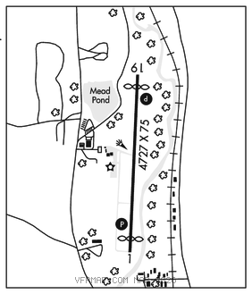
RWY 01–19: H4727X75 (ASPH–GRVD) S–48.5, D–68 PCN 14 F/A/X/T HIRL 0.3% up N
RWY 01: PAPI(P2L)–GA 4.0° TCH 34′. Thld dsplcd 275′. Trees.
RWY 19: REIL. PAPI(P2L)–GA 3.75° TCH 50′. Thld dsplcd 333′. Road.
RUNWAY DECLARED DISTANCE INFORMATION
RWY 01: TORA–4727 TODA–4727 ASDA–4394 LDA–4119
RWY 19: TORA–4727 TODA–4727 ASDA–4452 LDA–4119
SERVICE: FUEL 100LL, JET A, A+ LGT ACTVT REIL Rwy 19; PAPI Rwy 01 and 19; HIRL Rwy 01–19–CTAF. Rwy 01 PAPI unusbl byd 4 deg left of cntrln. Rwy 19 PAPI unusbl byd 3 NM and 4 deg left of cntrln.
AIRPORT REMARKS: Attended Mon–Fri 1200–2000Z‡. Unattended Christmas. Self–svc fuel avbl 24/7 with credit card. Geese and deer on and invof arpt. Rwy 19 has 15′ dropoff 30′ from thld on west side. Rwy safety areas have depressions in sfc. Cold temperature airport. Altitude correction required at or below –24C. Overnight tie–down fee, fee waived with fuel purchase.
AIRPORT MANAGER: 607-334-9430
WEATHER DATA SOURCES: AWOS–3 119.025 (607) 336–8583.
COMMUNICATIONS: CTAF/UNICOM 122.8
BOSTON CENTER APP/DEP CON 133.25
CLEARANCE DELIVERY PHONE: For CD ctc Boston ARTCC at 603-879-6859.
RADIO AIDS TO NAVIGATION: NOTAM FILE BUF.
ROCKDALE (L) (L) VORW/DME 112.6 RKA Chan 73 N42°27.98′ W75°14.35′ 307° 14.0 NM to fld. 2032/11W.