DANE CO RGNL/TRUAX FLD (MSN)(KMSN) P (ANG ARNG) 5 NE UTC–6(–5DT) N43°08.39′
W89°20.25′ 887 B TPA–See Remarks Class I, ARFF Index C NOTAM FILE MSN MON Airport

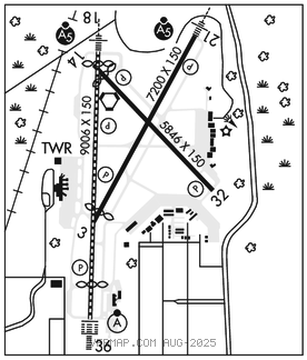
RWY 18–36: H9006X150 (CONC–GRVD) S–120, D–230, 2D–380, 2D/2D2–870 PCR 780 R/C/W/T HIRL CL
RWY 18: MALSR. PAPI(P4L)–GA 3.0° TCH 57′. RVR–TMR Thld dsplcd 400′. Hill.
RWY36: ALSF2. PAPI(P4L)–GA 3.0° TCH 59′. RVR–TMR Thld dsplcd 1001′.
RWY 03–21: H7200X150 (CONC–GRVD) S–120, D–230, 2D–380 PCR 780 R/D/W/T HIRL 0.4% up NE
RWY03: REIL. PAPI(P4L)–GA 3.0° TCH 49′. Thld dsplcd 431′. Trees.
RWY 21: MALSR. PAPI(P4L)–GA 3.0° TCH 53′. Road.
RWY 14–32: H5846X150 (CONC–GRVD) S–120, D–210, 2D–320 PCR 710 R/D/W/T HIRL
RWY 14: REIL. PAPI(P4L)–GA 3.0° TCH 45′. Thld dsplcd 477′.
RWY 32: REIL. PAPI(P4L)–GA 3.0° TCH 56′. Tree.
LAND AND HOLD–SHORT OPERATIONS
LDG RWY HOLD–SHORT POINT AVBL LDG DIST
RWY 03 14–32 3150
RWY 18 03–21 4800
RWY 21 RY 18–36 6450
RWY 32 18–36 5150
RWY 36 14–32 7050
RUNWAY DECLARED DISTANCE INFORMATION
RWY 03: TORA–7200 TODA–7200 ASDA–7200 LDA–6770
RWY 14: TORA–5846 TODA–5846 ASDA–5846 LDA–5369
RWY 18: TORA–9006 TODA–9006 ASDA–9006 LDA–8606
RWY 21: TORA–6770 TODA–6770 ASDA–7015 LDA–7015
RWY 32: TORA–5846 TODA–5846 ASDA–5846 LDA–5846
RWY 36: TORA–9006 TODA–9006 ASDA–9006 LDA–8006
ARRESTING GEAR/SYSTEM
RWY 18 BAK–14 BAK–12(B) (1900'). BAK–14 BAK–12(B) (1750').RWY 36 BAK–14 BAK–12(B) (1620'). RWY 21
SERVICE: S4 FUEL 100LL, JET A OX3, 4 LGT Actvt MALSR Rwy 18 and 21; REIL Rwy 03, 14 and 32; HIRL Rwy 03–21, 14–32, and 18–36–CTAF. When ATCT clsd HIRL Rwy 18–36 preset on low intst, to incr intst and actvt CTAF.
MILITARY– A–GEAR Rwy 18, 21, 36 BAK–14 arresting cable for MIL use only and retracted when not in use. JASU (AM32A–60B) (A/M32A–86D) FUEL A+, (C608–268–5018.) A++(Mil) (NC–100LL, A). FLUID PRESAIR De–Ice LHNIT LHOX OIL O–148
NOISE: Noise abatement proc in efct: dep acft utilize Rwy 03 & 36; arr acft utilize Rwy 18 & 21. Avoid overflight of Yahara River invof arpt blo 2000 ft AGL.
AIRPORT REMARKS: Attended continuously. Birds on and invof arpt. Turbo jet training flights prohibited. Twy F and G rstd to fighter acft only. E ramp btn Twy H and Twy M clsd to acft with wingspan more than 118′. Twys L1, L6, B5, E and Twy H north of Rwy 14–32 clsd to acft with wingspan more than 118′. E ramp and Twys B1, J and B north of Twy M clsd to acft with wingspan more than 150′. West ramp unctl, pushback at pilots discretion. West ramp rstd to air carrier acft only. Engine runup rstd to north hold bay only. Aviation fuel refueling avbl on East or South ramp only. Rwy 14 and Rwy 18 apch ends closely aligned, verify correct rwy and compass hdg prior to dep. Barricades along west edge of south ramp adj to mil ramp.
MILITARY REMARKS: RSTD Mil acft access and prk to west air carrier ramp proh. General avn svcs avbl on E ramp only MISC West ramp unctl, pushback at pilots discretion. TPA Military:ovhd tfc pat alt rstrd to 3500 ft MSL; Rwy 18–36 L turn. ANG PPR all act, contact email: 115FW.PPR.ORG@US.AF.MIL. Opr hr 1200–2230Z‡ Mon–Thurs, DSN 724–8642/8436, C608 245–4642/4436. DSN 724–8580 H24, C608 245–4580 H24. ARNG PPR, ARNG copter RQR svc, ctc Army OPS, Ltd TRAN SVC, opr 1300–2200Z‡ Mon, Tue; 1300–0400Z‡ Wed–Fri, CLSD Sat, Sun DSN 745–8310, C608–301–8310.
COMM ARNG OPS– 123.4, 299.9, 40.8.
AIRPORT MANAGER: 608-246-3380
WEATHER DATA SOURCES: ASOS (608) 249–0615 LLWAS. WSP.
COMMUNICATIONS: CTAF 119.3 ATIS 124.65 UNICOM 122.95
RCO 122.6 (GREEN BAY RADIO) (1200–0500Z‡)
®MADISON APP/DEP CON 120.1 EAST 135.45 WEST (1200–0500Z‡)
®CHICAGO CENTER APP/DEP CON 133.3 WEST (Hours Madison Apch clsd)
MADISON TOWER 119.3 (1200–0500Z‡) GND CON 121.9 CLNC DEL 121.625 (1200–0500Z‡)
CLEARANCE DELIVERY PHONE: For CD ctc Madison APP/DEP Con at 608-249-8240. When Madison Apch clsd, for CD ctc Chicago ARTCC at 630-906-8921.
AIRSPACE: CLASS C svc ctc APP CON svc 1200–0500Z‡; other times CLASS E.
RADIO AIDS TO NAVIGATION: NOTAM FILE MSN.
MADISON (L) (L) VORTACW 108.6 MSN Chan 23 N43°08.69′ W89°20.38′ at fld. 857/3E. mntrd by twr
TACAN AZIMUTH & DME unusable:
010°–070° byd 20 NM blo 4,500′
070°–210° byd 20 NM blo 3,500′
210°–240° byd 30 NM blo 4,000′
285°–010° byd 30 NM blo 4,000′
VOR portion unusable:
155°–230° byd 20 NM blo 2,800′
230°–155° byd 30 NM blo 2,800′
TACAN AZIMUTH unusable:
240°–285° byd 9 NM
TACAN DME unusable:
240°–285° byd 30 NM blo 4,000′
ILS/DME 110.1 I–DSZ Chan 38 Rwy 18. Class IIE. LOC and glideslope unmonitored when ATCT clsd.
ILS/DME 111.55 I–DQJ Chan 52(Y) Rwy 21. Class IC. Unmonitored when twr clsd. DME unusable byd 7.5 NM.
ILS/DME 110.1 I–MSN Chan 38 Rwy 36. Class III/E. LOC and glideslope unmonitored when ATCT clsd.