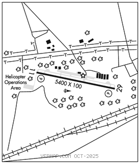
COATESVILLE
CHESTER CO G O CARLSON (MQS)(KMQS) 2 W UTC–5(–4DT) N39°58.74′ W75°51.93′ 660 B NOTAM FILE IPT

RWY 11–29: H5400X100 (ASPH–GRVD) S–30, D–48 HIRL 0.4% up E
RWY 11: REIL. PAPI(P4R)–GA 3.2° TCH 55′. Tree.
RWY 29: REIL. PAPI(P4L)–GA 3.0° TCH 57′. Trees.
SERVICE: S4 FUEL 100LL, JET A OX 1, 2, 3, 4 LGT Dusk–Dawn. ACTVT REIL Rwy 11–29; HIRL Rwy 11–29–CTAF. Rwy 11 VGSI unusbl byd 6 deg left of crs.
NOISE: Noise abatement procedures in effect ctc FBO 610–384–9000.
AIRPORT REMARKS: Attended 1100–0300Z‡. Migratory birds and deer on and invof arpt. Helicopter ops invof arpt south and southwest of Rwy 11 thld. For svc after hrs ctc 610–384–9000. Helicopter traffic requested to land and tkof from rwy only. Helicopter hover taxiing, tkofs and lndgs prohibited from Twy Alpha. Hover taxiing along Twy Alpha prohibited. Wheel taxi on txy or hover from rwy to ramp side parking spot by crossing perpendicular to Alpha. +164′ water twr 1343′ from Rwy 11 thld 1842′ right marked with strobe lgt dalgt hrs, standard obstruction lgt ngt hrs.
AIRPORT MANAGER: 610-383-6057
WEATHER DATA SOURCES: AWOS–3 126.25 (610) 384–6132.
COMMUNICATIONS: CTAF/UNICOM 122.7
®PHILADELPHIA APP/DEP CON 124.35
CLNC DEL 125.6
CLEARANCE DELIVERY PHONE: For CD ctc Philadelphia Apch at 800-354-9884.
RADIO AIDS TO NAVIGATION: NOTAM FILE IPT.
MODENA (L) (L) VORTACW 113.2 MXE Chan 79 N39°55.08′ W75°40.25′ 301° 9.7 NM to fld. 473/9W.
VOR unusable:
036°–046°
047°–057° byd 10 NM
058°–085°
170°–248° byd 27 NM blo 7,500′
170°–248° byd 30 NM blo 9,500′
170°–248° byd 8 NM blo 6,000′
268°–278° byd 28 NM
278°–290° blo 10,000′
290°–326°
ILS 108.5 I–MQS Rwy 29. Class IA.