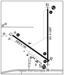
MASON CITY MUNI (MCW)(KMCW) 5 W UTC–6(–5DT) N43°09.47′ W93°19.88′
1213 B TPA–2013(800) ARFF Index–See Remarks NOTAM FILE MCW

RWY 18–36: H6501X150 (ASPH–GRVD) S–80, D–110, 2S–140, 2D–180 PCR 610 F/C/X/T HIRL 0.3% up N
RWY 18: MALS. VASI(V4L)–GA 3.0° TCH 39′.
RWY 36: MALSR. PAPI(P4L)–GA 2.9° TCH 62′.
RWY 12–30: H5502X150 (ASPH–GRVD) S–80, D–110, 2S–140, 2D–180 PCR 160 F/C/X/T MIRL 0.3% up NW
RWY 12: REIL. PAPI(P4L)–GA 3.0° TCH 39′. Tree.
RWY 30: PAPI(P4L)–GA 3.0° TCH 51′. Bldg.
RUNWAY DECLARED DISTANCE INFORMATION
RWY 12: TORA–5501 TODA–5501 ASDA–5501 LDA–5501
RWY 18: TORA–6501 TODA–6501 ASDA–6501 LDA–6501
RWY 30: TORA–5501 TODA–5501 ASDA–5501 LDA–5501
RWY 36: TORA–6501 TODA–6501 ASDA–6401 LDA–6401
SERVICE: S4 FUEL 100LL, JET A LGT Actvt HIRL Rwy 18–36; MIRL Rwy 12–30; REIL Rwy 12; MALS Rwy 18; MALSR Rwy 36; VASI Rwy 18; PAPI Rwy 12; 30 and 36–CTAF. All PAPIs on durg dalgt hrs.
AIRPORT REMARKS: Attended 1300–2300Z‡. Airport operations 641–430–0980. For svc or fuel after hrs PPR call 641–430–9898. Bird activity on and invof arpt. Class I, ARFF Index A. ARFF Index C available PPR ctc arpt ops 641–430–0980. Rwy 30 is calm wind rwy. Due to rwy and twy end elevation differentials and acft height; pilots may lose line of sight of other acft on opposing rwy and twy ends. All departure/arrival acft use CTAF. Ldg fee for all commercial operated acft.
AIRPORT MANAGER: 641-421-3397
WEATHER DATA SOURCES: ASOS 120.300 (641) 255–0381.
COMMUNICATIONS: CTAF/UNICOM 123.0
RCO 122.6 (FORT DODGE RADIO)
®MINNEAPOLIS CENTER APP/DEP CON 127.3
CLEARANCE DELIVERY PHONE: For CD if una to ctc on FSS freq, ctc Minneapolis ARTCC at 651-463-5588.
AIRSPACE: CLASS E.
RADIO AIDS TO NAVIGATION: NOTAM FILE MCW.
(VH) (H) VORW/DME 114.9 MCW Chan 96 N43°05.69′ W93°19.79′ 353° 3.8 NM to fld. 1209/6E.
ILS 109.5 I–MCW Rwy 36. Class IE. LOC unusable byd 27° right of course.