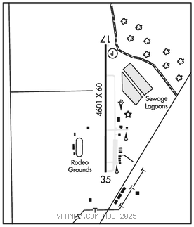
CHALLIS
CHALLIS (LLJ)(KLLJ) 1 NE UTC–7(–6DT) N44°31.42′ W114°13.08′ 5076 B NOTAM FILE LLJ

RWY 17–35: H4601X60 (ASPH) S–30 MIRL 1.5% up S
RWY 17: PAPI(P2L)–GA 4.0° TCH 40′.
RWY 35: P–line.
SERVICE: S4 FUEL 100, JET A LGT Rwy 17 PAPI unusbl byd 7 degs right and left of cntrln: Rwy 17 PAPI unusbl byd 2.5 NM fm thr due to trrn.
AIRPORT REMARKS: Attended Mon–Fri 1400–0000Z‡. Deer on and invof arpt. Be alert helicopter ops adj southeast end of arpt. Rwy 17–35 recommend land Rwy 17, tkf Rwy 35 when wind cond permit.
AIRPORT MANAGER: (208) 833-4617
WEATHER DATA SOURCES: ASOS 119.275 (208) 844–2785. SAWRS.
COMMUNICATIONS: CTAF/UNICOM 122.8
CLEARANCE DELIVERY PHONE: For CD ctc Salt Lake ARTCC at 801-320-2568.
RADIO AIDS TO NAVIGATION: NOTAM FILE SMN.
SALMON (VH) (DH) VORW/DME 113.5 LKT Chan 82 N45°01.28′ W114°05.05′ 178° 30.4 NM to fld. 926013E.
VOR unusable:
127°–135° byd 40 NM
136°–146° byd 40 NM blo 14,000′